 Filter: Categories of Wisconsin Historical Images
Filter: Subject of Shipping
Filter: Subject of water
Filter: Categories of Wisconsin Historical Images
Filter: Subject of Shipping
Filter: Subject of water
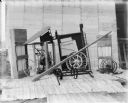
| Date: | 1900 |
|---|---|
| Description: | Corn binder dismantled for shipping. Some parts are crated. There is a white sheet behind the corn binder serving as a backdrop, and railroad tracks run al... |
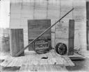
| Date: | 1900 |
|---|---|
| Description: | Binder dismantled for shipping. There is a white sheet behind the crates serving as a backdrop. In the background on the left are railroad tracks running a... |
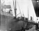
| Date: | 1900 |
|---|---|
| Description: | View down dock towards men unloading a binder on the gangway of a ship docked on the left. A woman is standing on the deck of the ship. |

| Date: | 1923 |
|---|---|
| Description: | This map includes an explanation that reads: "This chart shows the movement of barley on the Great Lakes, St. Lawrence River, and New York State Barge Cana... |

| Date: | 1923 |
|---|---|
| Description: | This map includes an explanation that reads: "This chart shows the movement of corn on the Great Lakes, St. Lawrence River, and New York State Barge Canal ... |

| Date: | 1923 |
|---|---|
| Description: | This map includes an explanation that reads: "This chart shows the easterly movement of flaxseed on the Great Lakes, St. Lawrence River, and New York State... |

| Date: | 1923 |
|---|---|
| Description: | This map includes an explanation that reads: "This chart shows the movement of grain on the Great Lakes, St. Lawrence River, and New York State Barge Canal... |

| Date: | 1923 |
|---|---|
| Description: | This map includes an explanation that reads: "This chart shows the movement of rye on the Great Lakes, St. Lawrence River, and New York State Barge Canal d... |

| Date: | 1923 |
|---|---|
| Description: | This map includes an explanation that reads: "This chart shows the movement of wheat on the Great Lakes, St. Lawrence River, and New York State Barge Canal... |

| Date: | 04 1926 |
|---|---|
| Description: | This blueprint mostly shows various numbers within the canal and bay. Lake Michigan and Harobor of Refuge are shown along the far right side. Near the harb... |

| Date: | 1858 |
|---|---|
| Description: | This map shows the proposed railways of the Tomah & Lake St. Croix Railroad (from Tomah to Hudson) and the St. Croix & Lake Superior Railroad (from Hudson ... |
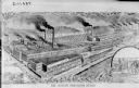
| Date: | 1900 |
|---|---|
| Description: | Elevated view of Deering Harvester Works. Includes insets: one in the bottom left corner is of a man using a horse-drawn mower, and the one in the bottom r... |

| Date: | 1924 |
|---|---|
| Description: | This map shows railroads, electric lines, and steamship lines. The left margin includes an index of principal cities, and the lower left corner includes a... |

| Date: | 1868 |
|---|---|
| Description: | This map includes a table of estimated costs "by Brev. Maj. Gen. G.K. Warren Maj. U.S.E., of improvement of Wis. River from his survey of 1867." Included a... |

| Date: | |
|---|---|
| Description: | View across water towards the lumber steamer Chas. B. Packard docked with a load of lumber. Several crew members are standing on the deck, and men a... |

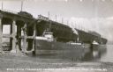
| Date: | 09 04 1925 |
|---|---|
| Description: | Elevated view of ship in docks. There is a line of railroad cars on the right. |
| Date: | 1935 |
|---|---|
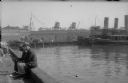
| Description: | The funnels (smokestacks) of two large steamships are visible over warehouse buildings on a pier of a southern American port. Both ships have nautical flag... |
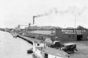
| Date: | 07 1936 |
|---|---|
| Description: | Elevated view of fishing tugs moored alongside the wharf at Marinette. Two automobiles are parked in the foreground, just in front of the Bridge Fish Co. b... |
| Date: | 1935 |
|---|---|
| Description: | Aerial view of crew members standing and sitting on the deck of the ore boat Captain Thomas Wilson in Ashland harbor. |
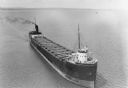
| Date: | 1935 |
|---|---|
| Description: | View from shoreline towards three ore boats at the Soo Line Railroad dock being loaded with iron ore. The first in line is the William B. Pilkey. |
If you didn't find the material you searched for, our Library Reference Staff can help.
Call our reference desk at 608-264-6535 or email us at: