Filter: Categories of Wisconsin Historical Images
Filter: Subject of Shipping
Filter: Reproduction Rights of For Sale
Filter: Subject of bays
Filter: Categories of Wisconsin Historical Images
Filter: Subject of Shipping
Filter: Reproduction Rights of For Sale
Filter: Subject of bays

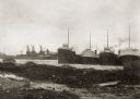
| Date: | 1885 |
|---|---|
| Description: | Ore dock of the Milwaukee, Lake Shore, and Western Railroad, with a pile of logs in the foreground and docked ships in the background. |

| Date: | 1920 |
|---|---|
| Description: | Caption reads: "Mammoth Ore Docks, Ashland, Wis." A building and roads are in the foreground. Several ore ships can be seen. |
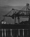
| Date: | 1914 |
|---|---|
| Description: | View of docks with ships tied up for the winter. The Reiss coal yard is in the background. |

| Date: | 1872 |
|---|---|
| Description: | This 1872 map shows the proposed route of a canal between Sturgeon Bay, on the Green Bay side of the Door Peninsula, and Lake Michigan. Depths in both Stur... |

| Date: | 1890 |
|---|---|
| Description: | This map of Superior shows city wards, bays, docks, some businesses and points of interest. Relief is shown by hachures. The back of the map features a typ... |

| Date: | 1932 |
|---|---|
| Description: | This map of Superior shows many points of interests including camping, fair grounds, docks, tourist attractions, lakes, roads, and waterways. |

| Date: | 1887 |
|---|---|
| Description: | This map shows lot and block numbers, established dock lines, docks, slips, railroads, and streets of West Superior in 1887. |

| Date: | 1889 |
|---|---|
| Description: | This map shows lot and block numbers, established dock lines, docks, slips, railroads, and streets of West Superior in 1889. |

| Date: | 01 06 1958 |
|---|---|
| Description: | Ahnapee & Western Railway Bridge construction. View is from Highway Bridge. There are ships on the right side beyond the bridge. The forested shoreline cur... |

| Date: | 01 06 1958 |
|---|---|
| Description: | Ahnapee & Western Railway Bridge from north side of frozen Sturgeon Bay. The bridge is made of wood (and steel supports???). There is a dock in the foregro... |

| Date: | 04 1926 |
|---|---|
| Description: | This blueprint mostly shows various numbers within the canal and bay. Lake Michigan and Harobor of Refuge are shown along the far right side. Near the harb... |

| Date: | 1868 |
|---|---|
| Description: | This map includes a table of estimated costs "by Brev. Maj. Gen. G.K. Warren Maj. U.S.E., of improvement of Wis. River from his survey of 1867." Included a... |
If you didn't find the material you searched for, our Library Reference Staff can help.
Call our reference desk at 608-264-6535 or email us at: