Filter: Categories of Wisconsin Historical Images
Filter: Subject of Schools
Filter: Subject of human settlements
Filter: County of Walworth
Filter: Categories of Wisconsin Historical Images
Filter: Subject of Schools
Filter: Subject of human settlements
Filter: County of Walworth
| Date: | 1870 |
|---|---|
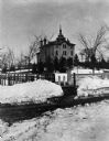
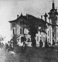
| Description: | State Normal School. A group of men are standing in the tall grass in the left foreground. |
| Date: | 1910 |
|---|---|
| Description: | Wisconsin State Normal School located on Main Street in Whitewater. Text reads: Dec. 9 "Dear Duan(??): How would you like to trade schools? This is where I... |
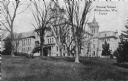
| Date: | 1925 |
|---|---|
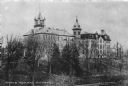
| Description: | Large trees grace the lawn of the State Normal School located on Main Street. Albert Salisbury, the first president of the school, envisioned the campus as... |
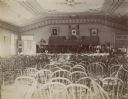
| Date: | |
|---|---|
| Description: | Interior view of the chapel at the Wisconsin School for the Deaf. Rows of empty, bow back chairs face a stage, where more chairs are set up under bunting a... |

| Date: | |
|---|---|
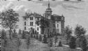
| Description: | Exterior view of the main building at the Wisconsin School for the Deaf. The building is surrounded by a lawn and a grove of trees. |

| Date: | |
|---|---|
| Description: | Letterhead of the Wisconsin School for the Deaf in Delavan, Wisconsin, with a background image of an elevated view of the school? and surrounding grounds p... |

| Date: | 1896 |
|---|---|
| Description: | This late 19th century map of Walworth County, Wisconsin, shows the township and range grid, towns, sections, villages and post offices, roads, railroads, ... |

| Date: | 1959 |
|---|---|
| Description: | This map of Lake Geneva has relief shown by contours and water depths shown by isolines. The map includes an index of schools, churches, public services, i... |

| Date: | 1858 |
|---|---|
| Description: | This map is hand-colored and mounted on cloth and shows lot and block numbers and dimensions, landownership, streets, railroads, selected buildings, fair g... |

| Date: | 1965 |
|---|---|
| Description: | This map shows proposed streets, arterial and collector streets, lot numbers and dimensions, parks, the disposal plant, a ball park, and school property. T... |

| Date: | 1890 |
|---|---|
| Description: | This map shows lot and block numbers and dimensions, landownership, city wards, buildings, streets, railroads, parks, cemeteries, churches, schools, and in... |
If you didn't find the material you searched for, our Library Reference Staff can help.
Call our reference desk at 608-264-6535 or email us at: