 Filter: Categories of Wisconsin Historical Images
Filter: Subject of School buildings
Filter: Year of 1800-1899
Filter: Categories of Wisconsin Historical Images
Filter: Subject of School buildings
Filter: Year of 1800-1899
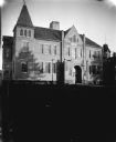
| Date: | 1897 |
|---|---|
| Description: | View across lawn towards a large brick school building. Identified as the high school built in 1897 in Black River Falls. |

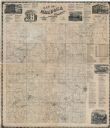
| Date: | 1857 |
|---|---|
| Description: | This map shows lot and block numbers, wards, roads, railroads, some landowners’ names, and selected buildings. The map includes an inset map of Glidden & L... |

| Date: | 1857 |
|---|---|
| Description: | This map shows lot and block numbers, wards, roads, railroads, some landowners’ names, and selected buildings. Lake Michigan, the Milwaukee River, and Glid... |

| Date: | 1857 |
|---|---|
| Description: | This map shows lot and block numbers, wards, roads, railroads, some landowners’ names, and selected buildings. Lake Michigan, the Milwaukee River, and Glid... |

| Date: | 1895 |
|---|---|
| Description: | Cover of a booklet about Hillside Home School for 1895-1896, the school's eighth year. Includes a circular framed photograph of the front of the school. |

| Date: | 01 1856 |
|---|---|
| Description: | This map shows lots, lots appropriated for churches and schools, streets, parks, court house, and land to be appropriated for railroad depots. An inset map... |

| Date: | 1891 |
|---|---|
| Description: | This hand-colored map shows platted additions and subdivisions, ward boundaries, schools, churches, railroads, cemeteries, parks, businesses, factories, an... |

| Date: | 1891 |
|---|---|
| Description: | This map shows vacant Southwick & Sellers lands, settlers' houses, Goodland Co. land, schools, churches, saw mills, roads, and railroads. A key in the uppe... |

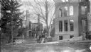
| Date: | 1867 |
|---|---|
| Description: | View across street towards the front of the 2nd Ward School building, which was located at 720 E. Gorham Street. |

| Date: | 1877 |
|---|---|
| Description: | This map is a photstat copy of the original and shows landownership, townships and sections, wagon roads, railroads, school houses, churches, cemeteries, m... |
| Date: | 1874 |
|---|---|
| Description: | This map shows townships and sections, land ownership and acreages, churches, schools, cemeteries, roads, railroads, and projected railroads. The map inclu... |

| Date: | 1894 |
|---|---|
| Description: | This map shows railroads, street railways, ward lines, land parcels, streets, schools and public buildings. Ward lines are highlighted in red. Lake Michiga... |
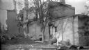
| Date: | 1893 |
|---|---|
| Description: | Exterior view of the Edgewood Villa, built in 1854, which was bought by Governor C.C. (Cadwallader) Washburn in 1873. Later, the grounds and building becam... |
| Date: | 1893 |
|---|---|
| Description: | Group of people standing near two buildings which burned in 1893. In the center background is Edgewood Villa, a home purchased by Governor C.C. (Cadwallade... |

| Date: | 1874 |
|---|---|
| Description: | Birds-eye view of Appleton Wisconsin. In the foreground are people fishing, strolling, and looking over the canal towards the Fox River. Streets and buildi... |

| Date: | 1838 |
|---|---|
| Description: | Drawing of Shullsburg. There is a numbered key on the left that reads, at top: "Explanation. Nos. Denote present Site." Streets are named on the map and ma... |
If you didn't find the material you searched for, our Library Reference Staff can help.
Call our reference desk at 608-264-6535 or email us at: