 Filter: Categories of Wisconsin Historical Images
Filter: Subject of Sawmills
Filter: Year of 1900-1999
Filter: Subject of dwellings
Filter: Categories of Wisconsin Historical Images
Filter: Subject of Sawmills
Filter: Year of 1900-1999
Filter: Subject of dwellings

| Date: | 1905 |
|---|---|
| Description: | Elevated view of Soldiers' Grove with a bridge in the foreground. |
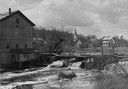
| Date: | 1948 |
|---|---|
| Description: | Elevated view from shoreline towards the opposite shoreline towards the Buettner mill on the left, and the river with a dam, on the right. In the backgroun... |
| Date: | 1912 |
|---|---|
| Description: | Buildings at a logging camp or sawmill operated by the International Harvester Company. A horse is in the right foreground. |
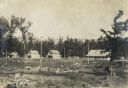
| Date: | 1912 |
|---|---|
| Description: | A woman stands in the doorway of the first in a line of houses at an International Harvester logging camp or sawmill. |

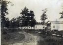
| Date: | 1912 |
|---|---|
| Description: | Two buildings, including the office of Dr. A.B. Allston (left), at an International Harvester logging camp or sawmill. People can be seen standing on the p... |

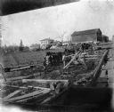
| Date: | 1908 |
|---|---|
| Description: | Emerson Brothers Sawmill with large piles of cut trees in the foreground. |
| Date: | 1903 |
|---|---|
| Description: | Rudolf Herrling farm looking west from the sawmill platform. Three men are near horses and carts in a fenced-in area. In the background is the farmhouse. |

| Date: | 1900 |
|---|---|
| Description: | Shows lands belonging to Wisconsin Timber and Land Co., towns, post offices, saw mills, creameries, camps, churches, schools, farm houses, town halls, rail... |
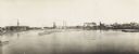
| Date: | 1900 |
|---|---|
| Description: | Semi-panoramic view of a river town showing extensive sawmill operations. |

| Date: | 1909 |
|---|---|
| Description: | This map shows vacant Wisconsin Central Ry. lands, settlers houses, lands sold by Wisconsin Central Ry., schools, churches, saw mills, and roads; also show... |

| Date: | 1909 |
|---|---|
| Description: | This map covers Iron and Price Counties and portions of Sawyer and Oneida Counties. The map shows vacant and sold Wis. Central Ry. land, settlers houses, s... |

| Date: | 1912 |
|---|---|
| Description: | This map shows land for sale by the Rusk Farm Company. Caption reads, "Look carefully at the map. Notice the thickly settled country on all sides of our la... |

| Date: | 1901 |
|---|---|
| Description: | A Sanborn map of Tomahawk featuring the Bay Mill Company's lumber yard. |

| Date: | 1950 |
|---|---|
| Description: | Subject: "Sawmills — UD-14A Power Unit." Where Taken: "SE." Information with photograph reads: "L.C. Wilson, Dundee, Miss. has no trouble obtaining lumber ... |
If you didn't find the material you searched for, our Library Reference Staff can help.
Call our reference desk at 608-264-6535 or email us at:
