Filter: Categories of Wisconsin Historical Images
Filter: Subject of Sawmills
Filter: Year of 1800-1899
Filter: Year of 1860-1869
Filter: Categories of Wisconsin Historical Images
Filter: Subject of Sawmills
Filter: Year of 1800-1899
Filter: Year of 1860-1869
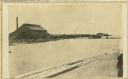
| Date: | 1867 |
|---|---|
| Description: | Mill dam and sash factory. "The Northwester Gateway. Excursion to Lake Superior, June 1867. Photographed and Published by J. Carbutt, 131 Lake St., Chicago... |

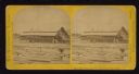
| Date: | 1867 |
|---|---|
| Description: | Birds-eye drawing of Appleton, Outagamie Co., depicting street names and street layout, houses, the Fox River, the court house, jail, school houses, Lawren... |
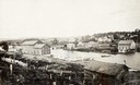
| Date: | 1868 |
|---|---|
| Description: | View of the Baraboo River and surrounding structures. |
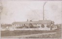
| Date: | 07 30 1865 |
|---|---|
| Description: | An exterior view across water of Robert Stephenson & Company Mill, which was a steam mill. |

| Date: | 1861 |
|---|---|
| Description: | This 1861 map of Columbia County, Wisconsin, shows the township and range grid, towns, sections, cities and villages, railroads, roads, property owners and... |

| Date: | 1862 |
|---|---|
| Description: | This map shows landownership on a military reserve, private claims, buildings (including Fort Howard and U.S. sawmill), swamps, public barns and fields, an... |

| Date: | 1866 |
|---|---|
| Description: | A colorful map of Gilpin County, the central gold region of Colorado, surveyed by Charles W. Morse and George Hill. |
If you didn't find the material you searched for, our Library Reference Staff can help.
Call our reference desk at 608-264-6535 or email us at: