 Filter: Categories of Wisconsin Historical Images
Filter: Subject of Sawmills
Filter: Subject of transportation
Filter: Year of 1900-1999
Filter: Categories of Wisconsin Historical Images
Filter: Subject of Sawmills
Filter: Subject of transportation
Filter: Year of 1900-1999

| Date: | 1905 |
|---|---|
| Description: | Elevated view of Soldiers' Grove with a bridge in the foreground. |

| Date: | 1913 |
|---|---|
| Description: | Bird's-eye map of Superior. "The New Steel Center." |

| Date: | 05 02 1964 |
|---|---|
| Description: | Sitting on the school lawn, students draw Highway 51, Marathon Mill, Rib mountain and the Wisconsin River. |

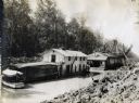
| Date: | 1910 |
|---|---|
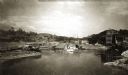
| Description: | Chippewa Falls from the south side of the river below the falls. Includes the Sheely House Tavern, railway buildings, box cars, a train with five passenger... |
| Date: | 1910 |
|---|---|
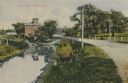
| Description: | Distant view of the mill, with a stream leading to it, and a road paralleling the stream on the right. Caption reads: "The Old Mill, Delavan, Wis." |
| Date: | 1900 |
|---|---|
| Description: | View up the Eau Claire River from the Dewey Street Bridge. The view shows the dam and linen mill and the site of the lower sawmill (called the "steam mill"... |
| Date: | 1950 |
|---|---|
| Description: | A sawmill run on the Menominee Indian Reservation. |
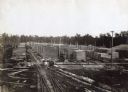
| Date: | 1912 |
|---|---|
| Description: | Exterior view of an International Harvester sawmill, with logs stacked on railroad cars on a railroad track. |
| Date: | 1912 |
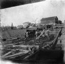
|---|---|
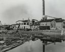
| Description: | Buildings and boats on water at or near an International Harvester logging camp or sawmill. A man is standing on a crane on the right side of the image, an... |
| Date: | 1912 |
|---|---|
| Description: | Buildings at a logging camp or sawmill operated by the International Harvester Company. A horse is in the right foreground. |
| Date: | 1912 |
|---|---|
| Description: | Elevated view of two men with donkeys stand on railroad tracks at an International Harvester sawmill lumberyard. |
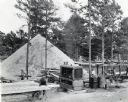
| Date: | 1938 |
|---|---|
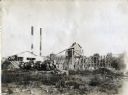
| Description: | An International PD-80 diesel power unit used to power an A.B. Carroll Lumber Company sawmill. Several men are at work on the site; trees, and what appears... |

| Date: | 1902 |
|---|---|
| Description: | Two panoramic bird's-eye views of the Paine Lumber Company, including the general plant, sawmill, and lumber yards. Heading at the top says: Home of Wiscon... |

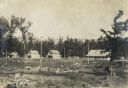
| Date: | 1930 |
|---|---|
| Description: | View of William Bonifas Lumber Mill showing the mill buildings, a water tower, "Railroad Crossing" sign, an automobile, lumber stacked on railroad cars, an... |
| Date: | 1903 |
|---|---|
| Description: | Rudolf Herrling farm looking west from the sawmill platform. Three men are near horses and carts in a fenced-in area. In the background is the farmhouse. |

| Date: | 1909 |
|---|---|
| Description: | A map of Langlade County, Wisconsin that shows townships and ranges, towns, cities and villages, wagon roads, churches, schools, sawmills, town halls, chee... |

| Date: | 1915 |
|---|---|
| Description: | This 1915 map of Lincoln County, Wisconsin, shows the township and range grid, towns, cities and villages, lakes and streams, residences, churches, school ... |

| Date: | 1914 |
|---|---|
| Description: | This 1914 map of Price County, Wisconsin, shows land for sale by the Good Land Company and Dewitt van Ostrand of Phillips. Also shown are the township and ... |

| Date: | 1900 |
|---|---|
| Description: | This 1900 map shows the township and range system, sections, cities and villages, railroads, roads, vacant land and land sold by the Wisconsin Central Rail... |

| Date: | 1909 |
|---|---|
| Description: | This 1909 map of Taylor County, Wisconsin, shows the township and range grid, towns, sections, cities and villages, settlers houses, schools, churches, saw... |
If you didn't find the material you searched for, our Library Reference Staff can help.
Call our reference desk at 608-264-6535 or email us at: