 Filter: Categories of Wisconsin Historical Images
Filter: Subject of Sawmills
Filter: Subject of transportation
Filter: Categories of Wisconsin Historical Images
Filter: Subject of Sawmills
Filter: Subject of transportation

| Date: | 1912 |
|---|---|
| Description: | This map shows land for sale by the Rusk Farm Company. Caption reads, "Look carefully at the map. Notice the thickly settled country on all sides of our la... |

| Date: | 1866 |
|---|---|
| Description: | A colorful map of Gilpin County, the central gold region of Colorado, surveyed by Charles W. Morse and George Hill. |

| Date: | |
|---|---|
| Description: | Ektachrome postcard of the blacksmith shop next to a stream. Text on reverse reads: "The Blacksmith Shop was Sylvanus Wade's first venture in Greenbush.... |

| Date: | 1901 |
|---|---|
| Description: | A Sanborn map of Tomahawk featuring the Bay Mill Company's lumber yard. |
| Date: | |
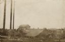
|---|---|
| Description: | View of a sawmill. A man is standing near a horse on the right. The building in the back has many broken windows. Caption reads: "Mill Scene, Kelly, Wiscon... |
| Date: | 08 1937 |
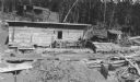
|---|---|
| Description: | Lumber is stacked in three large piles behind a small wooden shed. There is machinery in front of the shed on the right, and what appears to be a saw pit o... |

| Date: | 07 1936 |
|---|---|
| Description: | Stacks of logs cover a large flat area in the foreground, and in the distance is a complex of buildings at a sawmill. There are many large stacks of lumber... |
| Date: | 1909 |
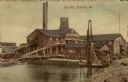
|---|---|
| Description: | View of a sawmill next to a river. Conveyor ramps are leading into the building. Caption reads: "Saw Mill, Marinette, Wis." |
| Date: | 1908 |
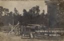
|---|---|
| Description: | View of a portable mill, a wagon, and lumber in a forest clearing. Caption reads: "Portable Mill at Butler's Camp, Mattoon, Wis." |

| Date: | 1875 |
|---|---|
| Description: | Elevated view of several buildings, with bridge and railroad tracks, and the Fox River. In the foreground on the right is the Commercial House, with three ... |
If you didn't find the material you searched for, our Library Reference Staff can help.
Call our reference desk at 608-264-6535 or email us at:

