Filter: Categories of Wisconsin Historical Images
Filter: Subject of Sawmills
Filter: Subject of transportation
Filter: Subject of land use
Filter: Categories of Wisconsin Historical Images
Filter: Subject of Sawmills
Filter: Subject of transportation
Filter: Subject of land use

| Date: | 05 02 1964 |
|---|---|
| Description: | Sitting on the school lawn, students draw Highway 51, Marathon Mill, Rib mountain and the Wisconsin River. |
| Date: | 1875 |
|---|---|
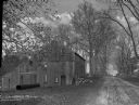
| Description: | View, through a cornfield, of people, a store, a sawmill and wagons. Moscow was platted in 1850 by an Englishman, Chauncy Smith, who dammed the Bluemound ... |
| Date: | |
|---|---|
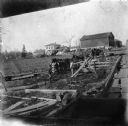
| Description: | View from roof of wagons lined up by the Herrling sawmill. |
| Date: | 1903 |
|---|---|
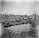
| Description: | Rudolf Herrling farm looking west from the sawmill platform. Three men are near horses and carts in a fenced-in area. In the background is the farmhouse. |

| Date: | |
|---|---|
| Description: | Two men posed standing outside a wooden building with a tall smokestack, probably a power plant for a sawmill. Two men are posed sitting in two wagons, eac... |

| Date: | |
|---|---|
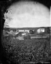
| Description: | View across yard of men and children posed near what is probably Warrens Mill. Men and children are posed standing, sitting in lumber wagons, on horses, an... |

| Date: | |
|---|---|
| Description: | View down hill of three women, three men, and a boy and girl posed standing in different locations around a sawmill by a shoreline, possibly the Lath Mill.... |

| Date: | |
|---|---|
| Description: | Large group of men posed standing in front of a sawmill. Three men are posed standing in a wagon pulled by a team of two horses wearing fly-nets. One man w... |

| Date: | 1914 |
|---|---|
| Description: | Map shows school houses, creameries, post offices, saw mills, grist mills, churches, cemeteries, town halls, stores, roads, state roads, and railroads. "Co... |

| Date: | 1953 |
|---|---|
| Description: | This mid 20th century map of Vilas County and northeastern Oneida County, Wisconsin, shows the township and range grid, sections, cities and villages, rail... |

| Date: | 1892 |
|---|---|
| Description: | Map shows farms, schools, saw mills, townships, railroads, and roads. Counties are labelled and are outlined in yellow and pink. On the upper right and le... |

| Date: | 1857 |
|---|---|
| Description: | This map shows section corners, quarter section corners, foundry, steam saw mill, steam grist mill, planning mill, court house, baptist church, congregatio... |
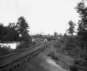
| Date: | 05 1902 |
|---|---|
| Description: | Alexander Krueger and Ernst Goetsch standing along a railroad track leading to a sawmill. The mill stais at the end of the tracks, which is lined with tree... |

| Date: | 1912 |
|---|---|
| Description: | This map shows land for sale by the Rusk Farm Company. Caption reads, "Look carefully at the map. Notice the thickly settled country on all sides of our la... |
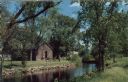
| Date: | |
|---|---|
| Description: | Ektachrome postcard of the blacksmith shop next to a stream. Text on reverse reads: "The Blacksmith Shop was Sylvanus Wade's first venture in Greenbush.... |
If you didn't find the material you searched for, our Library Reference Staff can help.
Call our reference desk at 608-264-6535 or email us at: