 Filter: Categories of Wisconsin Historical Images
Filter: Subject of Sawmills
Filter: Subject of transportation
Filter: Subject of land
Filter: Categories of Wisconsin Historical Images
Filter: Subject of Sawmills
Filter: Subject of transportation
Filter: Subject of land

| Date: | 1881 |
|---|---|
| Description: | Bird's-eye map of Marinette, with insets. |

| Date: | 1905 |
|---|---|
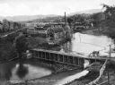
| Description: | Elevated view of Soldiers' Grove with a bridge in the foreground. |

| Date: | 1886 |
|---|---|
| Description: | Bird's-eye view of Ashland, on the shores of Lake Superior, with insets of The Apostle Islands Chequamagon Bay & Ashland, and Distances from Ashland. |

| Date: | 1867 |
|---|---|
| Description: | Birds-eye drawing of Appleton, Outagamie Co., depicting street names and street layout, houses, the Fox River, the court house, jail, school houses, Lawren... |

| Date: | 1913 |
|---|---|
| Description: | Bird's-eye map of Superior. "The New Steel Center." |

| Date: | 1886 |
|---|---|
| Description: | Bird's-eye map of Washburn on Lake Superior. There is an inset of Washburn, Chequamagon and the Apostle Islands. |

| Date: | 05 02 1964 |
|---|---|
| Description: | Sitting on the school lawn, students draw Highway 51, Marathon Mill, Rib mountain and the Wisconsin River. |
| Date: | |
|---|---|
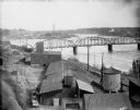
| Description: | Elevated view of the riverfront, railroad tracks, and river, "as viewed from Joseph McGuire's." |

| Date: | |
|---|---|
| Description: | A peaceful view of a pond and mill, featuring a small dog sitting in a boat, which rests on the shore. |

| Date: | |
|---|---|
| Description: | Elevated view down hill toward old mill with a small bridge in the foreground, and another arched bridge over a steep-sided stream in City Park. Paths and ... |
| Date: | |
|---|---|
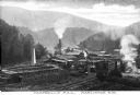
| Description: | Elevated view of Campbell's Mill, which specialized in lumber. Situated in the midst of the forest are smokestacks, railroad tracks, and several buildings.... |

| Date: | |
|---|---|
| Description: | View looking down hill toward the sawmill and logs floating in the pond. Company outbuildings are on the left, with a smokestack and silo. A water tower is... |
| Date: | |
|---|---|
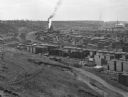
| Description: | Elevated view from hill toward a lumberyard, with small workers' homes on the left. A dirt path and wooden fence surround the lumberyard, which is filled w... |
| Date: | |
|---|---|
| Description: | Elevated view of the mill, dam, and railroad tracks, and forests surrounding the area. The lumber mill itself, with main building complex and smokestack is... |

| Date: | |
|---|---|
| Description: | View from shoreline of lumber mill on the bank of the Chippewa River, with steam emitting from the smokestacks. A bridge over the river is in the right bac... |

| Date: | |
|---|---|
| Description: | View down hill of three women, three men, and a boy and girl posed standing in different locations around a sawmill by a shoreline, possibly the Lath Mill.... |
| Date: | |
|---|---|
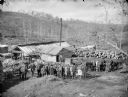
| Description: | View down hill of a large group of men, some displaying horses, in front of a sawmill and its power plant. One of the men is holding a dog, and two of the ... |

| Date: | 1909 |
|---|---|
| Description: | A map of Langlade County, Wisconsin that shows townships and ranges, towns, cities and villages, wagon roads, churches, schools, sawmills, town halls, chee... |

| Date: | 1915 |
|---|---|
| Description: | This 1915 map of Lincoln County, Wisconsin, shows the township and range grid, towns, cities and villages, lakes and streams, residences, churches, school ... |
If you didn't find the material you searched for, our Library Reference Staff can help.
Call our reference desk at 608-264-6535 or email us at:
