 Filter: Categories of Wisconsin Historical Images
Filter: Subject of Sawmills
Filter: Subject of service industries
Filter: Categories of Wisconsin Historical Images
Filter: Subject of Sawmills
Filter: Subject of service industries

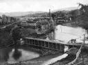
| Date: | 1910 |
|---|---|
| Description: | Chippewa Falls from the south side of the river below the falls. Includes the Sheely House Tavern, railway buildings, box cars, a train with five passenger... |
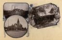
| Date: | 1900 |
|---|---|
| Description: | Composite of views of Oakwood Beach Lodge, Pioneer Presbyterian Church and a sawmill. |
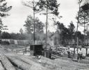
| Date: | 09 14 1938 |
|---|---|
| Description: | Men working outdoors at a sawmill powered by an International PD-80 Diesel power unit purchased by the A.B. Carroll Lumber Company. |
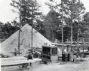
| Date: | 1938 |
|---|---|
| Description: | An International PD-80 diesel power unit used to power an A.B. Carroll Lumber Company sawmill. Several men are at work on the site; trees, and what appears... |
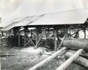
| Date: | 05 12 1939 |
|---|---|
| Description: | International P-40 power unit under a shed at a sawmill. Logs are piled near the sheltered work area, and a man works beside them. |
| Date: | |
|---|---|
| Description: | Elevated view of the mill, dam, and railroad tracks, and forests surrounding the area. The lumber mill itself, with main building complex and smokestack is... |

| Date: | 1915 |
|---|---|
| Description: | This 1915 map of Lincoln County, Wisconsin, shows the township and range grid, towns, cities and villages, lakes and streams, residences, churches, school ... |

| Date: | 1914 |
|---|---|
| Description: | This 1914 map of Price County, Wisconsin, shows land for sale by the Good Land Company and Dewitt van Ostrand of Phillips. Also shown are the township and ... |

| Date: | 1871 |
|---|---|
| Description: | This map of Barron County, Wisconsin, shows the township and range grid, towns, sections, cities and villages, post offices, dwellings, schools, roads, swa... |

| Date: | 1870 |
|---|---|
| Description: | This 1870 map of Brown County, Wisconsin, shows the township and range grid, towns, sections, cities, villages and post offices, land ownership, roads, rai... |

| Date: | 1861 |
|---|---|
| Description: | This 1861 map of Columbia County, Wisconsin, shows the township and range grid, towns, sections, cities and villages, railroads, roads, property owners and... |

| Date: | 1901 |
|---|---|
| Description: | Map shows lakes, rivers, schools, saw mills, post offices, creameries, and churches. Includes significant manuscript annotations showing township divisions... |

| Date: | 1900 |
|---|---|
| Description: | Shows lands belonging to Wisconsin Timber and Land Co., towns, post offices, saw mills, creameries, camps, churches, schools, farm houses, town halls, rail... |

| Date: | 1953 |
|---|---|
| Description: | This mid 20th century map of Vilas County and northeastern Oneida County, Wisconsin, shows the township and range grid, sections, cities and villages, rail... |

| Date: | 1914 |
|---|---|
| Description: | Map shows townships, schools, saw mills, roads, railroads, and post offices. Text on the top left has a box of towns with land in Marathon County. Top righ... |

| Date: | 1886 |
|---|---|
| Description: | This map has relief shown by hachures and includes a list of plats in order of date of record, laws which vacate plats, plats not shown as upon the county ... |

| Date: | 1888 |
|---|---|
| Description: | This map has relief shown by hachures and features inset maps of a plat of E.D. Clinton and Blackwell’s add’n to the City of La Crosse. Wards (1-10) shaded... |

| Date: | 1870 |
|---|---|
| Description: | This map is ink and color on tracing cloth and shows Iron Ridge, the hotel and saw mill at Iron Ridge Village, Milwaukee & St. Paul Railway, plank road, an... |

| Date: | 1902 |
|---|---|
| Description: | This map shows townships, land parcels, schools, rivers, lakes, creameries, churches, cemeteries, roads, post offices, town halls, saw mills, roads and sto... |
If you didn't find the material you searched for, our Library Reference Staff can help.
Call our reference desk at 608-264-6535 or email us at:
