 Filter: Categories of Wisconsin Historical Images
Filter: Subject of Sawmills
Filter: Subject of railroads
Filter: Categories of Wisconsin Historical Images
Filter: Subject of Sawmills
Filter: Subject of railroads

| Date: | 1886 |
|---|---|
| Description: | This map has relief shown by hachures and includes a list of plats in order of date of record, laws which vacate plats, plats not shown as upon the county ... |

| Date: | 1888 |
|---|---|
| Description: | This map has relief shown by hachures and features inset maps of a plat of E.D. Clinton and Blackwell’s add’n to the City of La Crosse. Wards (1-10) shaded... |

| Date: | 09 1891 |
|---|---|
| Description: | Sanborn map of Hurley, featuring the Village of Gile and the Montreal River Lumber Company. |

| Date: | 1898 |
|---|---|
| Description: | Sanborn map of Hurley featuring the Village of Gile. |

| Date: | 1870 |
|---|---|
| Description: | This map is ink and color on tracing cloth and shows Iron Ridge, the hotel and saw mill at Iron Ridge Village, Milwaukee & St. Paul Railway, plank road, an... |

| Date: | 1855 |
|---|---|
| Description: | This map is ink, pen, and watercolor on paper and shows plat of the town, local streets, lots by number, U.S. subdivisions in red lines, Mineral Point Rail... |
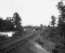
| Date: | 05 1902 |
|---|---|
| Description: | Alexander Krueger and Ernst Goetsch standing along a railroad track leading to a sawmill. The mill stais at the end of the tracks, which is lined with tree... |

| Date: | 1876 |
|---|---|
| Description: | This map is ink on tracing cloth and shows the Black River, French Slough, Little French Slough, the southern portion of North La Crosse, the Milwaukee & S... |

| Date: | 06 1923 |
|---|---|
| Description: | Sanborn map of Ashland, which includes Chequamegon Bay. |

| Date: | 1909 |
|---|---|
| Description: | This map shows vacant Wisconsin Central Ry. lands, settlers houses, lands sold by Wisconsin Central Ry., schools, churches, saw mills, and roads; also show... |

| Date: | 1909 |
|---|---|
| Description: | This map covers Iron and Price Counties and portions of Sawyer and Oneida Counties. The map shows vacant and sold Wis. Central Ry. land, settlers houses, s... |

| Date: | 1912 |
|---|---|
| Description: | This map shows land for sale by the Rusk Farm Company. Caption reads, "Look carefully at the map. Notice the thickly settled country on all sides of our la... |
If you didn't find the material you searched for, our Library Reference Staff can help.
Call our reference desk at 608-264-6535 or email us at: