 Filter: Categories of Wisconsin Historical Images
Filter: Subject of Sawmills
Filter: Subject of dwellings
Filter: Categories of Wisconsin Historical Images
Filter: Subject of Sawmills
Filter: Subject of dwellings

| Date: | |
|---|---|
| Description: | Elevated view of a large group of men, children and horses posed standing in front of a sawmill, probably a mill located in McKenna. |
| Date: | |
|---|---|
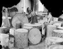
| Description: | Man posing standing among tree sections on a sawmill floor. |

| Date: | 1888 |
|---|---|
| Description: | This late 19th century map of Price County, Wisconsin, shows landownership and waterfront acreages, the township and range system, towns, cities and villag... |

| Date: | 1871 |
|---|---|
| Description: | This map of Barron County, Wisconsin, shows the township and range grid, towns, sections, cities and villages, post offices, dwellings, schools, roads, swa... |

| Date: | 1900 |
|---|---|
| Description: | Shows lands belonging to Wisconsin Timber and Land Co., towns, post offices, saw mills, creameries, camps, churches, schools, farm houses, town halls, rail... |

| Date: | 1842 |
|---|---|
| Description: | Relief shown by hachures. Shows furnaces, saw mills, houses, roads, grist mills, entries, reservations, and diggings. "Compiled by order of the Board of C... |

| Date: | 1857 |
|---|---|
| Description: | Relief shown by hachures. "Lith. of Ed. Mendel, Chicago." Shows townships and sections, rivers, roads, railroads, houses, flour mills, saw mills, furnaces... |
| Date: | 1900 |
|---|---|
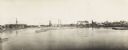
| Description: | Semi-panoramic view of a river town showing extensive sawmill operations. |

| Date: | 1891 |
|---|---|
| Description: | This map shows vacant Southwick & Sellers lands, settlers' houses, Goodland Co. land, schools, churches, saw mills, roads, and railroads. A key in the uppe... |

| Date: | 1909 |
|---|---|
| Description: | This map shows vacant Wisconsin Central Ry. lands, settlers houses, lands sold by Wisconsin Central Ry., schools, churches, saw mills, and roads; also show... |

| Date: | 1909 |
|---|---|
| Description: | This map covers Iron and Price Counties and portions of Sawyer and Oneida Counties. The map shows vacant and sold Wis. Central Ry. land, settlers houses, s... |

| Date: | 1912 |
|---|---|
| Description: | This map shows land for sale by the Rusk Farm Company. Caption reads, "Look carefully at the map. Notice the thickly settled country on all sides of our la... |

| Date: | 1901 |
|---|---|
| Description: | A Sanborn map of Tomahawk featuring the Bay Mill Company's lumber yard. |

| Date: | 1950 |
|---|---|
| Description: | Subject: "Sawmills — UD-14A Power Unit." Where Taken: "SE." Information with photograph reads: "L.C. Wilson, Dundee, Miss. has no trouble obtaining lumber ... |

| Date: | 1875 |
|---|---|
| Description: | Elevated view of several buildings, with bridge and railroad tracks, and the Fox River. In the foreground on the right is the Commercial House, with three ... |
If you didn't find the material you searched for, our Library Reference Staff can help.
Call our reference desk at 608-264-6535 or email us at:

