 Filter: Categories of Wisconsin Historical Images
Filter: Subject of Sawmills
Filter: Subject of dwellings
Filter: Subject of land
Filter: Categories of Wisconsin Historical Images
Filter: Subject of Sawmills
Filter: Subject of dwellings
Filter: Subject of land

| Date: | 1881 |
|---|---|
| Description: | Bird's-eye map of Marinette, with insets. |

| Date: | 1905 |
|---|---|
| Description: | Elevated view of Soldiers' Grove with a bridge in the foreground. |

| Date: | 1886 |
|---|---|
| Description: | Bird's-eye view of Ashland, on the shores of Lake Superior, with insets of The Apostle Islands Chequamagon Bay & Ashland, and Distances from Ashland. |

| Date: | 1850 |
|---|---|
| Description: | Painting depicting Chippewa Falls and the first sawmill on the Chippewa River, built by Jean Brunet. The residence of H.S. Allen, one of the owners of the... |

| Date: | 1867 |
|---|---|
| Description: | Birds-eye drawing of Appleton, Outagamie Co., depicting street names and street layout, houses, the Fox River, the court house, jail, school houses, Lawren... |
| Date: | |
|---|---|
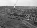
| Description: | Elevated view from hill toward a lumberyard, with small workers' homes on the left. A dirt path and wooden fence surround the lumberyard, which is filled w... |
| Date: | |
|---|---|
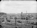
| Description: | View from hill of lumber operation, with stacks of timber and a sawmill in operation, probably McKenna in eastern Jackson County. |

| Date: | |
|---|---|
| Description: | Lumberyard full of logs and a sawmill in the distance, probably McKenna in eastern Jackson County. |

| Date: | 1888 |
|---|---|
| Description: | This late 19th century map of Price County, Wisconsin, shows landownership and waterfront acreages, the township and range system, towns, cities and villag... |

| Date: | 1871 |
|---|---|
| Description: | This map of Barron County, Wisconsin, shows the township and range grid, towns, sections, cities and villages, post offices, dwellings, schools, roads, swa... |

| Date: | 1857 |
|---|---|
| Description: | Relief shown by hachures. "Lith. of Ed. Mendel, Chicago." Shows townships and sections, rivers, roads, railroads, houses, flour mills, saw mills, furnaces... |

| Date: | 1901 |
|---|---|
| Description: | A Sanborn map of Tomahawk featuring the Bay Mill Company's lumber yard. |
If you didn't find the material you searched for, our Library Reference Staff can help.
Call our reference desk at 608-264-6535 or email us at: