 Filter: Categories of Wisconsin Historical Images
Filter: Subject of Sawmills
Filter: Subject of dwellings
Filter: Creator Name of Unknown
Filter: Categories of Wisconsin Historical Images
Filter: Subject of Sawmills
Filter: Subject of dwellings
Filter: Creator Name of Unknown

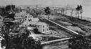
| Date: | 1905 |
|---|---|
| Description: | Elevated view of Soldiers' Grove with a bridge in the foreground. |

| Date: | 1850 |
|---|---|
| Description: | Painting depicting Chippewa Falls and the first sawmill on the Chippewa River, built by Jean Brunet. The residence of H.S. Allen, one of the owners of the... |
| Date: | 1948 |
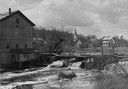
|---|---|
| Description: | Elevated view from shoreline towards the opposite shoreline towards the Buettner mill on the left, and the river with a dam, on the right. In the backgroun... |
| Date: | 1885 |
|---|---|
| Description: | Elevated view of Shell Lake looking towards the sawmills. |
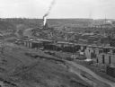
| Date: | |
|---|---|
| Description: | Elevated view from hill toward a lumberyard, with small workers' homes on the left. A dirt path and wooden fence surround the lumberyard, which is filled w... |

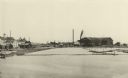
| Date: | |
|---|---|
| Description: | Elevated view of the lumber mill and surrounding area. In the foreground is a pond with logs floating in it. Along the shoreline are the buildings and comp... |

| Date: | 1908 |
|---|---|
| Description: | Emerson Brothers Sawmill with large piles of cut trees in the foreground. |
| Date: | 1887 |
|---|---|
| Description: | A view at the mouth of the Menominee River showing Ludington Wells and Van Schaick's mills. |
| Date: | 1890 |
|---|---|
| Description: | A view of Rudolph Herrling's sawmill and log yard in front of the Herling farm. |
| Date: | 1903 |
|---|---|
| Description: | Rudolf Herrling farm looking west from the sawmill platform. Three men are near horses and carts in a fenced-in area. In the background is the farmhouse. |
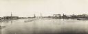
| Date: | 1900 |
|---|---|
| Description: | Semi-panoramic view of a river town showing extensive sawmill operations. |

| Date: | 1891 |
|---|---|
| Description: | This map shows vacant Southwick & Sellers lands, settlers' houses, Goodland Co. land, schools, churches, saw mills, roads, and railroads. A key in the uppe... |

| Date: | 1909 |
|---|---|
| Description: | This map shows vacant Wisconsin Central Ry. lands, settlers houses, lands sold by Wisconsin Central Ry., schools, churches, saw mills, and roads; also show... |

| Date: | 1875 |
|---|---|
| Description: | Elevated view of several buildings, with bridge and railroad tracks, and the Fox River. In the foreground on the right is the Commercial House, with three ... |
If you didn't find the material you searched for, our Library Reference Staff can help.
Call our reference desk at 608-264-6535 or email us at: