 Filter: Categories of Wisconsin Historical Images
Filter: Subject of Sawmills
Filter: Subject of barns
Filter: Categories of Wisconsin Historical Images
Filter: Subject of Sawmills
Filter: Subject of barns
| Date: | |
|---|---|
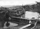
| Description: | Elevated view of the mill, dam, and railroad tracks, and forests surrounding the area. The lumber mill itself, with main building complex and smokestack is... |
| Date: | 1903 |
|---|---|
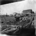
| Description: | Rudolf Herrling farm looking west from the sawmill platform. Three men are near horses and carts in a fenced-in area. In the background is the farmhouse. |

| Date: | 1900 |
|---|---|
| Description: | This photostat of a manuscript map originally drawn in 1829 shows landownership, buildings, including Fort Howard and U.S. sawmill, swamps, public barns an... |

| Date: | 1862 |
|---|---|
| Description: | This map shows landownership on a military reserve, private claims, buildings (including Fort Howard and U.S. sawmill), swamps, public barns and fields, an... |

| Date: | 1914 |
|---|---|
| Description: | Drawing of a sawmill inside three-sided roofed shed, open to the front. Attached to a barn along the back wall. |

| Date: | 1935 |
|---|---|
| Description: | Original caption reads: "Building an empire? The sawmill breaks down and what a crowd of onlookers to 'supervise' repairs." |
If you didn't find the material you searched for, our Library Reference Staff can help.
Call our reference desk at 608-264-6535 or email us at: