 Filter: Categories of Wisconsin Historical Images
Filter: Subject of Rural areas
Filter: Subject of wetlands
Filter: Categories of Wisconsin Historical Images
Filter: Subject of Rural areas
Filter: Subject of wetlands

| Date: | 1780 |
|---|---|
| Description: | This map shows the townships, parishes, cities, towns, plantations, lakes, rivers, swamps, and roads near the coast of South Carolina and Georgia. Emphasis... |

| Date: | 1975 |
|---|---|
| Description: | View through snow-covered cattails after a winter snowfall towards a house on the left, and a barn and a silo on the right. |
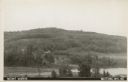
| Date: | 1907 |
|---|---|
| Description: | Text on front reads: "Mount Morris. Wautoma, Wis." A view of Mount Morris from above the shore of a lake or pond. A dwelling and perhaps a farm can be seen... |
If you didn't find the material you searched for, our Library Reference Staff can help.
Call our reference desk at 608-264-6535 or email us at: