 Filter: Categories of Wisconsin Historical Images
Filter: Subject of Rural areas
Filter: Subject of sailing ships
Filter: Categories of Wisconsin Historical Images
Filter: Subject of Rural areas
Filter: Subject of sailing ships

| Date: | 1870 |
|---|---|
| Description: | Bird's-eye view of the city of Manitowoc with a population of 5,168 inhabitants as it appears in 1870, the year the village was granted a city charter by t... |
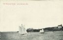
| Date: | |
|---|---|
| Description: | View across water towards two schooners off the shore of Madeline Island, one of the islands that comprise the Apostle Islands in Lake Superior. Two large ... |

| Date: | 1790 |
|---|---|
| Description: | This map of the north eastern states shows roads, rivers, lakes, waterfalls, mountains, cities, forts, mills, the Oneida Reservation, and "New York Donatio... |

| Date: | 1776 |
|---|---|
| Description: | Map of New Jersey and New York, showing cities, forts, roads, counties, townships, land grants, rivers, lakes and several topographical features. Much of t... |

| Date: | 1900 |
|---|---|
| Description: | Three photographs taped together form a panoramic view from the top of the wooden tower built by George Brumder in 1892. The tower was built on Brumder's s... |
If you didn't find the material you searched for, our Library Reference Staff can help.
Call our reference desk at 608-264-6535 or email us at: