 Filter: Categories of Wisconsin Historical Images
Filter: Subject of Rural areas
Filter: Subject of mountains
Filter: Categories of Wisconsin Historical Images
Filter: Subject of Rural areas
Filter: Subject of mountains
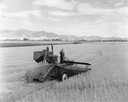
| Date: | 1939 |
|---|---|
| Description: | Elevated view of men harvesting grain with a McCormick-Deering 12 foot experimental combine (harvester-thresher) pulled by a Farmall M tractor. There is a ... |

| Date: | 1961 |
|---|---|
| Description: | Aerial view of a small settlement in the mountains, Luang Prabang vicinity, Laos. A narrow dirt road winds across the terrain and some buildings and an air... |

| Date: | 1961 |
|---|---|
| Description: | Keukacham Meo settlement, Laos with American special forces and Lao infantrymen. Two soldiers talk near a tent and another works atop a mud-spattered jeep. |

| Date: | 1961 |
|---|---|
| Description: | A woman carrying a basket on her back leads a mule laden with bundles across an airstrip at Keukacham village, Laos. There are 55-gallon drums near a tent,... |
| Date: | 1961 |
|---|---|
| Description: | A woman leads a mule laden with bundles across the airstrip at the village of Keukacham, Laos. A young mule follows. In the background at the base of a hil... |

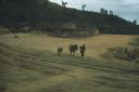
| Date: | 1961 |
|---|---|
| Description: | View of Keukacham village, Laos from behind a tank. A partially thatched building is in the foreground and other buildings on a dirt road are visible in th... |

| Date: | 1961 |
|---|---|
| Description: | Elevated view of Keukacham village, Laos. Three soldiers stand talking in the foreground by a large, open, white tent. In the background is a rubble pile, ... |

| Date: | 1961 |
|---|---|
| Description: | Aerial view of Keukacham village, Laos including landing strip with helicopter. The small settlement is clearly visible contrasted against the verdant gree... |

| Date: | 1790 |
|---|---|
| Description: | This map of the north eastern states shows roads, rivers, lakes, waterfalls, mountains, cities, forts, mills, the Oneida Reservation, and "New York Donatio... |

| Date: | 1770 |
|---|---|
| Description: | The south west sheet of a four sheet map of Virginia, showing the counties, mountains, rivers, court houses, a few cities, and mills. A few Plantations ar... |

| Date: | 1776 |
|---|---|
| Description: | Map of New Jersey and New York, showing cities, forts, roads, counties, townships, land grants, rivers, lakes and several topographical features. Much of t... |
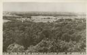
| Date: | 1907 |
|---|---|
| Description: | Text on the front: "View from the Top of the Mountain, Elevation 1233 ft. Mt. Morris, Wis." View of trees and fields from the highest point in Waushara Cou... |
If you didn't find the material you searched for, our Library Reference Staff can help.
Call our reference desk at 608-264-6535 or email us at: