 Filter: Categories of Wisconsin Historical Images
Filter: Subject of Rural areas
Filter: Type of Map or Atlas
Filter: Subject of lakes
Filter: Categories of Wisconsin Historical Images
Filter: Subject of Rural areas
Filter: Type of Map or Atlas
Filter: Subject of lakes

| Date: | 1876 |
|---|---|
| Description: | A hand-colored map on six sheets, this map of Juneau County indicates the locations of townships and sections, landowners and acreages, roads, wagon roads,... |

| Date: | 1909 |
|---|---|
| Description: | Bird's-eye view of Lake Geneva from the south extending to Waukesha and Milwaukee in the north. Delavan Lake and Lake Como are identified. Several electric... |

| Date: | 1927 |
|---|---|
| Description: | This Blue line print map shows trade area boundaries, lakes, farm homes, railways, high schools, public highways, and townships. A symbol key is included i... |

| Date: | 08 1960 |
|---|---|
| Description: | This map shows a detailed account of southwestern Wisconsin. Individual settlers, the type of trees that grow in given areas, the quality of the soil (labe... |

| Date: | 1790 |
|---|---|
| Description: | This map of the north eastern states shows roads, rivers, lakes, waterfalls, mountains, cities, forts, mills, the Oneida Reservation, and "New York Donatio... |

| Date: | 1776 |
|---|---|
| Description: | Map of New Jersey and New York, showing cities, forts, roads, counties, townships, land grants, rivers, lakes and several topographical features. Much of t... |

| Date: | 1780 |
|---|---|
| Description: | This map shows the townships, parishes, cities, towns, plantations, lakes, rivers, swamps, and roads near the coast of South Carolina and Georgia. Emphasis... |
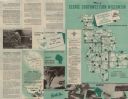
| Date: | 1953 |
|---|---|
| Description: | This map shows the locations of many scenic areas in La Crosse, Vernon, Crawford, Richland, Grant, and Iowa Counties. On the front side of the map, there i... |
If you didn't find the material you searched for, our Library Reference Staff can help.
Call our reference desk at 608-264-6535 or email us at: