Filter: Categories of Wisconsin Historical Images
Filter: Subject of Roads
Filter: Year of 1800-1899
Filter: County of Winnebago
Filter: Categories of Wisconsin Historical Images
Filter: Subject of Roads
Filter: Year of 1800-1899
Filter: County of Winnebago

| Date: | 1870 |
|---|---|
| Description: | This bird's-eye-view map shows roads, a river with boats, and homes. The bottom margin of the map includes an index. |

| Date: | 1833 |
|---|---|
| Description: | Map of part of the military road from Fort Crawford to Fort Howard. "Recorded on pages 668.669 Book B." Surveyed by Lieut. Center. Scale: 2 miles = 1 inch. |
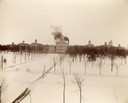
| Date: | 1893 |
|---|---|
| Description: | Elevated view of the Northern Hospital for the Insane and its front grounds. |

| Date: | 1877 |
|---|---|
| Description: | View across road of the Eastern District Norwegian Synod, May 31-June 6, 1877, at the Immanuel Norwegian Evangelical Lutheran Church (2 1/2 miles west of L... |
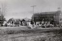
| Date: | 1888 |
|---|---|
| Description: | View across unpaved road towards construction workers at the site of the new city hall. William Waters, architect. |

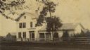
| Date: | 1868 |
|---|---|
| Description: | The Philteus Sawyer residence located on the northwest corner of Algoma and West Algoma Streets. Sawyer was mayor of Oshkosh from 1863-1864, and became a U... |

| Date: | 1863 |
|---|---|
| Description: | View across street towards Senator Philetus Sawyer's residence. Sawyer was elected to the U.S. Senate in 1881. People are posing in horse-drawn vehicles in... |

| Date: | 1890 |
|---|---|
| Description: | View across road towards a group of children standing in front of school buildings. Caption reads: "High and Manual Training School, Omro, Wis." |

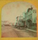
| Date: | 1871 |
|---|---|
| Description: | Stereograph. In the right background is the building of the Trade Reporter newspaper at the corner of Main and High Streets; across the street from it is J... |

| Date: | 1871 |
|---|---|
| Description: | Stereograph. In the right background is the building of the Trade Reporter newspaper at the corner of Main and High Streets; across the street from it is J... |
| Date: | 1871 |
|---|---|
| Description: | A stereograph of the town square and Main Street. The three-story building visible in the center of the photograph was operated as the National Hotel. It w... |
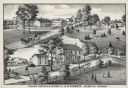
| Date: | 1880 |
|---|---|
| Description: | An illustration depicting the cheese factory and dry goods store of J.G. Pickett at Pickett's Station. |

| Date: | 1862 |
|---|---|
| Description: | This 1862 map of Winnebago County, Wisconsin, shows the township and range grid, towns, sections, cities and villages, railroads, roads, property owners an... |

| Date: | 1855 |
|---|---|
| Description: | This 1855 map of Winnebago County, Wisconsin, shows the township and range grid, towns, cities, villages, and post offices, roads, and lakes and streams. |

| Date: | 1873 |
|---|---|
| Description: | This 1873 map of Winnebago County, Wisconsin, shows the township and range grid, towns, sections, cities and villages, landownership and acreages, roads, r... |

| Date: | 1897 |
|---|---|
| Description: | This 1897 map of Winnebago County, Wisconsin, shows the township and range grid, towns, sections, cities and villages, landownership and acreages, rural re... |

| Date: | 1872 |
|---|---|
| Description: | Shows landowners, buildings, lot numbers, roads and railroads. Includes Menasha business directory. |

| Date: | 06 1890 |
|---|---|
| Description: | This map shows building use, railroads, tramways, lumber yards, roads, watchman’s stations, and steam pipes. Also included is text about buildings, Clapp a... |
If you didn't find the material you searched for, our Library Reference Staff can help.
Call our reference desk at 608-264-6535 or email us at: