 Filter: Categories of Wisconsin Historical Images
Filter: Subject of Roads
Filter: Subject of writing
Filter: Categories of Wisconsin Historical Images
Filter: Subject of Roads
Filter: Subject of writing

| Date: | 1930 |
|---|---|
| Description: | The front and back of a postcard featuring a drawing of the Detroit skyline as seen from Windsor, Ontario that was sent by Alice and Floyd Quinney during t... |

| Date: | 1863 |
|---|---|
| Description: | This map is a hand-colored, pen and ink, drawing by Ole R. Dahl of Co. B, 15 Wisconsin Infantry shows the battlefield at Stones River, depicting roads, str... |
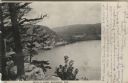
| Date: | 1906 |
|---|---|
| Description: | View from bluff of Devil's Lake. A road runs along the far shoreline. Caption reads: "Devil's Lake, Baraboo, Wis." |
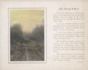
| Date: | 1920 |
|---|---|
| Description: | A hand-tinted photograph of a rutted, one lane country road is mounted with a printed border on a sheet of beige paper with a short essay printed alongside... |

| Date: | 1776 |
|---|---|
| Description: | This was one of the first maps available for the general British populace featuring America during the Revolutionary War. It includes forts, cities, topogr... |
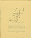
| Date: | 1906 |
|---|---|
| Description: | A drawing of The Gang's camp on a hill next to Eagle River. The drawing includes the river, a road, and a bridge. Arrows drawn on the river show the direct... |
If you didn't find the material you searched for, our Library Reference Staff can help.
Call our reference desk at 608-264-6535 or email us at: