 Filter: Categories of Wisconsin Historical Images
Filter: Subject of Roads
Filter: Subject of streams
Filter: Categories of Wisconsin Historical Images
Filter: Subject of Roads
Filter: Subject of streams

| Date: | 1936 |
|---|---|
| Description: | This map is red and black ink on tracing cloth and is oriented with north to the upper left. This hand-drawn map shows a central portion of the military ro... |

| Date: | 1874 |
|---|---|
| Description: | This map shows lakes, rivers, state, county, and town boundaries, as well as railroads completed, in progress, and contemplated. The map includes a color d... |

| Date: | 1871 |
|---|---|
| Description: | Birds eye map of Brodhead, WI depicts street names and street locations, houses, and trees. A reference key at the bottom of the map shows the locations of... |
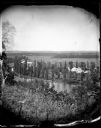
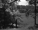
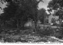
| Date: | |
|---|---|
| Description: | View from hill over a valley dotted with farmsteads and a meandering stream in the foreground. A group of three or four people are posing at the opposite s... |

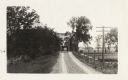
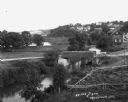
| Date: | 1950 |
|---|---|
| Description: | Aerial view of main street. There is a bridge with a stream flowing under it in the foreground. |
| Date: | |
|---|---|
| Description: | The Milwaukee Journal Pathfinder car driving from a road onto a bridge. |
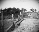
| Date: | |
|---|---|
| Description: | A man fishes from an earthen bridge. There is a house or barn in the background. |
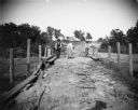
| Date: | |
|---|---|
| Description: | Two men fish from an earthen bridge while a woman stands holding a fish. There is a house or barn in the background. |
| Date: | 07 04 1965 |
|---|---|
| Description: | A rural valley with a stream running through the pasture. In the background, a farm is visible through the trees. |
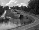
| Date: | |
|---|---|
| Description: | Five combined locks between the Hudson River and Lake Champlain in a wooded area. A dirt road runs along one side and a stepped concrete stream-bed runs a... |
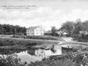
| Date: | |
|---|---|
| Description: | View over stream toward the Hawthorne House, childhood home of American novelist and short story writer Nathaniel Hawthorne (7/4/1804 – 5/19/1864) built ar... |
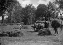
| Date: | |
|---|---|
| Description: | Two men and a boy are shown gathering hay. The hay is being loaded onto a wagon pulled by two horses. A brook and a road are in the background. Caption rea... |
| Date: | |
|---|---|
| Description: | View looking north from a covered bridge, including a rocky stream-bed and a tree-lined dirt road with houses and other wooden buildings. Caption reads, "V... |
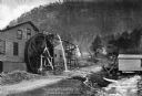
| Date: | |
|---|---|
| Description: | View toward a mill with a large water wheel and spring branch, near King Solomon's Cave. A man is posed standing next to the middle of the water wheel. Cap... |

| Date: | 1864 |
|---|---|
| Description: | View down to valley of Union soldiers posing on the roof of a log building. A log bridge crosses a stream, and many trees are on the hillsides. Plate 05... |

| Date: | 10 1884 |
|---|---|
| Description: | Sanborn insurance map of Black River Falls covering the area bordered by the Black River on the East, 3rd Street on the West, Johnson Street on the North, ... |

| Date: | |
|---|---|
| Description: | View of a bridge over a stream. In the foreground is a tree. Residential homes are in the distance. |
| Date: | |
|---|---|
| Description: | Elevated view of a stream with a dam and a bridge. There is a small fenced garden along the water. In the distance is a hillside with houses. |

| Date: | 1863 |
|---|---|
| Description: | This map is a hand-colored, pen and ink, drawing by Ole R. Dahl of Co. B, 15 Wisconsin Infantry shows the battlefield at Stones River, depicting roads, str... |

| Date: | 1865 |
|---|---|
| Description: | This map is a pen and ink tracing. Union positions are shown in blue and Confederate positions are shown in red. Roads, vegetation, and streams are labeled... |
If you didn't find the material you searched for, our Library Reference Staff can help.
Call our reference desk at 608-264-6535 or email us at: