 Filter: Categories of Wisconsin Historical Images
Filter: Subject of Roads
Filter: Subject of shipping
Filter: Categories of Wisconsin Historical Images
Filter: Subject of Roads
Filter: Subject of shipping
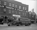
| Date: | 09 26 1935 |
|---|---|
| Description: | Whalen Transfer and Storage building, 605 University Avenue, with a company truck/trailer parked in front. Also seen is Kapec Furniture Co., 607 University... |

| Date: | 1885 |
|---|---|
| Description: | Ore dock of the Milwaukee, Lake Shore, and Western Railroad, with a pile of logs in the foreground and docked ships in the background. |

| Date: | 1920 |
|---|---|
| Description: | Caption reads: "Mammoth Ore Docks, Ashland, Wis." A building and roads are in the foreground. Several ore ships can be seen. |
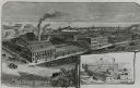
| Date: | 1883 |
|---|---|
| Description: | Etched print of factory with inset of Bay State Works in lower right corner. Lake with ships in background, with busy, buggy covered roads in foreground. ... |
| Date: | 1890 |
|---|---|
| Description: | Elevated view of brewing company and surrounding roads. On the road in front of the buildings are horse-drawn carts carrying barrels, a trolley car, and pe... |
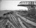
| Date: | 10 28 1938 |
|---|---|
| Description: | Elevated view of railroad yard and railroads cars on Jones Island. On the right is a large derrick or crane, and in the background are a number of freighte... |

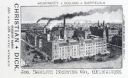
| Date: | 1902 |
|---|---|
| Description: | Two panoramic bird's-eye views of the Paine Lumber Company, including the general plant, sawmill, and lumber yards. Heading at the top says: Home of Wiscon... |

| Date: | |
|---|---|
| Description: | View of town toward Tongass Narrows where a ship sails on the water. |

| Date: | |
|---|---|
| Description: | Aerial view of town, showing the shoreline of Lake Superior, ore docks, roads, houses, buildings, trees, and smokestacks. Text describing this photograph s... |

| Date: | 1872 |
|---|---|
| Description: | This 1872 map shows the proposed route of a canal between Sturgeon Bay, on the Green Bay side of the Door Peninsula, and Lake Michigan. Depths in both Stur... |

| Date: | 1932 |
|---|---|
| Description: | This map of Superior shows many points of interests including camping, fair grounds, docks, tourist attractions, lakes, roads, and waterways. |

| Date: | 1887 |
|---|---|
| Description: | This map shows lot and block numbers, established dock lines, docks, slips, railroads, and streets of West Superior in 1887. |

| Date: | 1889 |
|---|---|
| Description: | This map shows lot and block numbers, established dock lines, docks, slips, railroads, and streets of West Superior in 1889. |

| Date: | 1902 |
|---|---|
| Description: | This map is a chart of Milwaukee Harbor that displays local streets, bridges, roads, railroads, public buildings, businesses, factories, dry docks, parks, ... |

| Date: | 1924 |
|---|---|
| Description: | This map shows railroads, electric lines, and steamship lines. The left margin includes an index of principal cities, and the lower left corner includes a... |
If you didn't find the material you searched for, our Library Reference Staff can help.
Call our reference desk at 608-264-6535 or email us at: