 Filter: Categories of Wisconsin Historical Images
Filter: Subject of Roads
Filter: Subject of prairies
Filter: Categories of Wisconsin Historical Images
Filter: Subject of Roads
Filter: Subject of prairies

| Date: | 1839 |
|---|---|
| Description: | This map shows the township and section grid, lakes, rivers, swamps, prairies, roads, and proposed canals in the area of Wisconsin south of Lake Winnebago ... |

| Date: | 1840 |
|---|---|
| Description: | This hand-colored map shows the township and section grid in southeastern Wisconsin, covering the area west to Sugar River and Four Lakes region and north ... |

| Date: | 05 1846 |
|---|---|
| Description: | Hand-colored map of southeastern Wisconsin showing the counties of Dodge, Jefferson, Rock, Walworth, Racine (including modern-day Kenosha County), Waukesha... |

| Date: | 1848 |
|---|---|
| Description: | Wisconsin became the thirtieth state in 1848. Drawn that same year, this map shows township lines, roads, villages, mills, railroads, prairies, swamps, can... |

| Date: | 1925 |
|---|---|
| Description: | Elevated view of Mount Vernon from the a grassy hill. |

| Date: | 1858 |
|---|---|
| Description: | An ink on paper map of Milwaukee County and the eastern portion of Waukesha County that shows the townships of Oak Creek, Franklin, Greenfield, Wauwatosa, ... |

| Date: | 1974 |
|---|---|
| Description: | This 1974 map is a reproduction of the original survey maps of the Four Lakes region of Dane County, Wisconsin. It shows sections, lakes, rivers, wetlands,... |

| Date: | 1840 |
|---|---|
| Description: | This manuscript map by Increase Lapham shows the railroads, roads, wetlands, lakes and streams, dams, prairies, and settlers in the eastern half of Waukesh... |

| Date: | 1836 |
|---|---|
| Description: | Map shows rivers, creeks, roads, trails, mills, and town of Madison. Includes significant manuscript annotations; Sheet 1 is watercolor on lithographed map... |
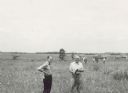
| Date: | 06 1957 |
|---|---|
| Description: | Members of the Board for the Preservation of Scientific Areas inspect the Scuppernong Prairie Scientific Area. The Board furnished this photograph for the ... |
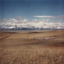
| Date: | 1986 |
|---|---|
| Description: | View across valley towards missile silo, Minuteman F-8. In the foreground is prairie, in the far background are snow-capped mountains and foothills. This... |

| Date: | 1900 |
|---|---|
| Description: | This map shows portion of the military road from Fond du Lac to the Wisconsin River near Fort Winnebago, with mile markers and adjacent land use. A few pro... |

| Date: | 1782 |
|---|---|
| Description: | Map of America covering the Rio Grande to the Atlantic Ocean, showing boundaries, the colonies, cities, settlements, Native American lands and villages, m... |

| Date: | 10 1776 |
|---|---|
| Description: | Broadside map showing the British invasion of New York city in August and September of 1776. The map shows important cities, forts, roads, hills, mountains... |

| Date: | 1755 |
|---|---|
| Description: | Map of Virginia and parts of Maryland, North Carolina, and New Jersey. It shows borders, boundary lines, some Native American land, counties, cities, towns... |

| Date: | 1795 |
|---|---|
| Description: | Detailed map of Kentucky showing counties, cities, towns, Native American towns, forts, salt licks, roads, prairies, mountains, lakes, and rivers. Numerous... |

| Date: | 06 1950 |
|---|---|
| Description: | View across a gently sloping prairie field. Trees are in the distance, and power lines and a road are on the left. The Highway Commission descriptive remar... |
If you didn't find the material you searched for, our Library Reference Staff can help.
Call our reference desk at 608-264-6535 or email us at:
