 Filter: Categories of Wisconsin Historical Images
Filter: Subject of Roads
Filter: Subject of ocean
Filter: Categories of Wisconsin Historical Images
Filter: Subject of Roads
Filter: Subject of ocean
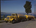
| Date: | 1951 |
|---|---|
| Description: | Color photograph of an International LD-400 series tanker truck owned by Eastern Washington Transports, Inc., on a road near the Port of Seattle. |

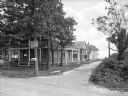
| Date: | |
|---|---|
| Description: | View of Plymouth Street looking towards the waterfront with large trees along the sidewalks. |
| Date: | |
|---|---|
| Description: | View from unpaved road toward houses down a side dirt road leading toward a beach in the background. A man stands on the porch of the house in the left for... |

| Date: | |
|---|---|
| Description: | Aerial view of a developed strip of land on Barnegat Bay showing the Atlantic ocean, houses, lakes, railroad tracks, a marina and a jetty in the distance. |

| Date: | 1920 |
|---|---|
| Description: | Elevated view of a pond in the foreground, and the seashore beyond. Houses are along the cliffs in the background. |
| Date: | 1920 |
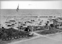
|---|---|
| Description: | Elevated view of the Dipsy Baths outbuilding and surrounding beach. Umbrellas are set up in the sand where people sunbathe or wade in the water, and an Ame... |

| Date: | |
|---|---|
| Description: | View of a cottage separated from Oyster Pond by fences and an unpaved road. |

| Date: | 1861 |
|---|---|
| Description: | A general map of Pennsylvania, Virginia, New Jersey and Delaware. Insets include maps of New Orleans, Baltimore, St. Louis, Charleston, Savannah, Washingto... |

| Date: | 1865 |
|---|---|
| Description: | This map of Maryland and Virginia shows railroads, rivers, cities and towns, and the positions of Confederate troops and defenses in Virginia in 1861. |

| Date: | 1899 |
|---|---|
| Description: | A map showing the shoreline of a portion of El Montecito, Santa Barbara County, California. The map shows properties along the Pacific Ocean, and may have ... |
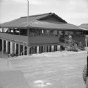
| Date: | 02 05 1944 |
|---|---|
| Description: | View from road of the exterior of the Allied Officers' Club in Port Moresby, New Guinea (present day Papua New Guinea). It is built on posts above the wate... |
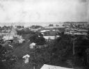
| Date: | 1902 |
|---|---|
| Description: | Elevated view of the city of Port Limon, Costa Rica with the Caribbean Sea in the background. Trees grow amongst the many commercial and residential buildi... |

| Date: | 1780 |
|---|---|
| Description: | This map shows the townships, parishes, cities, towns, plantations, lakes, rivers, swamps, and roads near the coast of South Carolina and Georgia. Emphasis... |
If you didn't find the material you searched for, our Library Reference Staff can help.
Call our reference desk at 608-264-6535 or email us at:
