 Filter: Categories of Wisconsin Historical Images
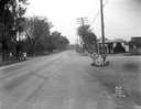
Filter: Subject of Roads
Filter: Subject of human settlements
Filter: Categories of Wisconsin Historical Images
Filter: Subject of Roads
Filter: Subject of human settlements
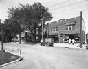
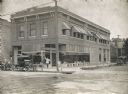
| Date: | 06 14 1927 |
|---|---|
| Description: | Storefronts of the Wisconsin School of Music, East Side Variety Store and Hess Grocery Market. Owned by the Hess family, this property was located at 154 A... |
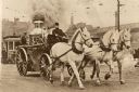
| Date: | 1900 |
|---|---|
| Description: | A steam fire engine of Milwaukee's Fire Company #2 drawn by three white horses racing to a fire. Prior motor driven fire equipment was a greater danger tha... |
| Date: | 1958 |
|---|---|
| Description: | 2700 Marshall Court, Doctor's Park, Shorewood Hills. |

| Date: | 1958 |
|---|---|
| Description: | Aerial view of Craig Avenue and Crestwood Avenue. |

| Date: | 1873 |
|---|---|
| Description: | Map of the township of Windsor, from the "Atlas of Dane County." |

| Date: | 1964 |
|---|---|
| Description: | Aerial view of the Milwaukee County Zoo grounds nearing its completion. |
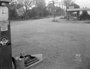
| Date: | 09 30 1933 |
|---|---|
| Description: | Gas station in a Trachte building on the corner of Highway 51 (Monona Drive) and Highway 30 (Cottage Grove Road). A "Johnson Winged 70 Gasoline" pump is in... |
| Date: | 09 30 1933 |
|---|---|
| Description: | A gas station in a Trachte building on the corner of Highway 51 (Monona Drive) and Highway 30 (Cottage Grove Road). "Johnson Gasoline," and "Defiance Spark... |
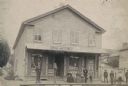
| Date: | 1888 |
|---|---|
| Description: | Exterior view of Charles Pfeifer's Drugstore, founded in 1858. From left to right are Charles Pfeifer, Fred Pfeifer, Mrs. Adam Heeb, Fulda Pfeifer, Mrs. Ch... |
| Date: | 1920 |
|---|---|
| Description: | Brick building containing the Olaf Noer Drugstore. A man (presumably Mr. Noer himself) poses in the doorway. |
| Date: | 11 04 1940 |
|---|---|
| Description: | James Robinson and E. Newton of the Professional Pharmacy prepare to load a Linde oxygen tank for home delivery. |

| Date: | 1856 |
|---|---|
| Description: | View looking west from Lake Michigan with several steam ships and sailing vessels in harbor. There is a lighthouse to left of center, along shoreline. |
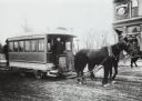
| Date: | 1890 |
|---|---|
| Description: | Man driving a horse-drawn trolley of the Milwaukee City Railroad Company on the Greenfield Avenue & Third Street line. The corner of a building advertising... |

| Date: | 1891 |
|---|---|
| Description: | Bird's-eye map of Wausau, looking north with ninety-eight businesses, industries, churches, schools, and civic buildings identified in location key below i... |
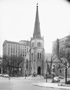
| Date: | 11 24 1946 |
|---|---|
| Description: | Built in 1855 and designed by Milwaukee architect James Douglas, the Grace Episcopal Church is the oldest remaining building on the Capitol Square. Grace E... |

| Date: | 1886 |
|---|---|
| Description: | Bird's-eye view of Bayfield, county seat of Bayfield County. On the lower left side is an inset for Bayfield and the Apostle Islands. |

| Date: | 1853 |
|---|---|
| Description: | Bird's-eye map of Milwaukee looking east toward Lake Michigan from a bluff, long since graded into a slope, at about 6th Street between Wisconsin Avenue an... |
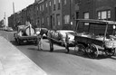
| Date: | 1967 |
|---|---|
| Description: | Man delivering water to a horse with an International C1300 (4x4) truck. The mobile water truck was owned by the Philadelphia Society for the Prevention of... |
If you didn't find the material you searched for, our Library Reference Staff can help.
Call our reference desk at 608-264-6535 or email us at:

