 Filter: Categories of Wisconsin Historical Images
Filter: Subject of Roads
Filter: Subject of grist mills
Filter: Categories of Wisconsin Historical Images
Filter: Subject of Roads
Filter: Subject of grist mills
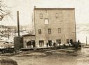
| Date: | 1885 |
|---|---|
| Description: | View of the Rockdale mill, a grist and sawmill built in 1847 by Thomas and Nathan Van Horn. A group of people are standing on a sidewalk or loading dock on... |
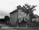
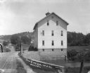
| Date: | 1934 |
|---|---|
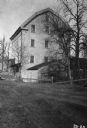
| Description: | Exterior of Concordia Mills, once a grain/grist mill. |
| Date: | 1930 |
|---|---|
| Description: | View of the Davidson Feed Mill near the Amnicon River. |
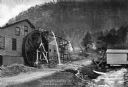
| Date: | 10 13 1911 |
|---|---|
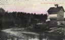
| Description: | Elevated view of a mill during a flood, with a man standing on the left between a bridge and the mill. A house is on the side of a tree-covered hill on the... |
| Date: | |
|---|---|
| Description: | View from road with a stone wall toward a small stone building housing a grist mill, with a large water wheel on the right side. Surrounding the grist mill... |

| Date: | |
|---|---|
| Description: | Elevated view of the old mill at State Mills Lake. A man, an automobile, and a horse and carriage are on the road in front of the mill. |
| Date: | |
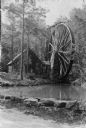
|---|---|
| Description: | View toward a mill with a large water wheel and spring branch, near King Solomon's Cave. A man is posed standing next to the middle of the water wheel. Cap... |
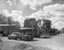
| Date: | |
|---|---|
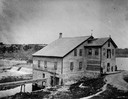
| Description: | Exterior of a feed mill erected About 1840. There is an advertisement for Quaker Ful-O-Pep feed above the entrance. Two pickup trucks are parked outside. |
| Date: | |
|---|---|
| Description: | Woman and girl posed sitting under a fur in a carriage pulled by a single horse by a wooden bridge. Behind them is a large wooden building, possibly a mill... |
| Date: | 1960 |
|---|---|
| Description: | Exterior of Olsen's Mill (Wayne Feeds) on Hwy 49, just north of Hwy 21. |

| Date: | 1914 |
|---|---|
| Description: | Map shows school houses, creameries, post offices, saw mills, grist mills, churches, cemeteries, town halls, stores, roads, state roads, and railroads. "Co... |

| Date: | 1842 |
|---|---|
| Description: | Relief shown by hachures. Shows furnaces, saw mills, houses, roads, grist mills, entries, reservations, and diggings. "Compiled by order of the Board of C... |

| Date: | 1976 |
|---|---|
| Description: | Panel title. Shows railroads, roads, highways, boundaries, dams, public hunting and fishing grounds, cemeteries, forest ranger stations, plant life, and s... |
| Date: | 1911 |
|---|---|
| Description: | View across bridge of mill. There is a man standing on a wagon near the side of the mill. Behind the mill is a steep hill, with a house visible among trees... |
| Date: | 1908 |
|---|---|
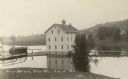
| Description: | View of the Rundolph Mill and dam near Muscoda. A man stands near the far side of the bridge on the left. The banks of the river are rocky cliffs, and a st... |
| Date: | |
|---|---|
| Description: | View from dirt road of a group of people (possibly employees) standing around the loading dock of the Hillsboro Mill. There is a steep, snow-covered hill i... |
| Date: | |
|---|---|
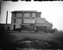
| Description: | View across road of men and children posing standing in front of a large three-story brick building, with signs that read: "Riverside Mill and Grain Compan... |
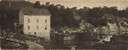
| Date: | 1909 |
|---|---|
| Description: | View across river toward the mill and dam. Caption reads: "Glen Lock Dam and Mill, Chippewa Falls, Wis." |

| Date: | 1900 |
|---|---|
| Description: | This photostat map shows private claim owners, natural meadows, roads, saw and grist mills, and Fort Howard. The upper right corner includes annotations an... |
If you didn't find the material you searched for, our Library Reference Staff can help.
Call our reference desk at 608-264-6535 or email us at:
