 Filter: Categories of Wisconsin Historical Images
Filter: Subject of Roads
Filter: Subject of fortification
Filter: Categories of Wisconsin Historical Images
Filter: Subject of Roads
Filter: Subject of fortification

| Date: | 1936 |
|---|---|
| Description: | This map is red and black ink on tracing cloth and is oriented with north to the upper left. This hand-drawn map shows a central portion of the military ro... |

| Date: | 1833 |
|---|---|
| Description: | Map of part of the military road from Fort Crawford to Fort Howard. "Recorded on pages 668.669 Book B." Surveyed by Lieut. Center. Scale: 2 miles = 1 inch. |
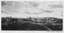
| Date: | |
|---|---|
| Description: | Photographic copy of a painting depicting Fort Winnebago, made by I. A. Ridgway of Portage, Wisconsin. Fort Winnebago was built in 1827 by Major William W... |
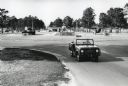
| Date: | 1964 |
|---|---|
| Description: | A man drives an International Harvester Scout past military vehicles on display near the entrance to Fort Stewart. |

| Date: | |
|---|---|
| Description: | An old woman known as Aunt Charlotte in an ox-drawn cart on fortress grounds. Caption reads: "Aunt Charlotte, Fortress Monroe, VA." |

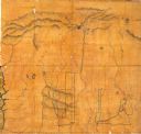
| Date: | |
|---|---|
| Description: | A hand-drawn map including the location of Daniel Boone's home and two forts, northeast of Lexington, Kentucky. |

| Date: | 1866 |
|---|---|
| Description: | View of earthworks at the battlefield at Resacca. Dirt roads cross the field in the distance, leading to a farm and what appears to be a river. Plate 22... |

| Date: | 1864 |
|---|---|
| Description: | View down to valley of Union soldiers posing on the roof of a log building. A log bridge crosses a stream, and many trees are on the hillsides. Plate 05... |

| Date: | 1850 |
|---|---|
| Description: | A hand-colored map showing portions of present-day Iron and Vilas counties north of the Manitowish River as part of the Upper Peninsula of Michigan. The Wi... |

| Date: | 1864 |
|---|---|
| Description: | This map created during the Civil War indicates Confederate fortifications, houses, names of residents, towns, roads, railroads, relief by hachures, draina... |

| Date: | 1864 |
|---|---|
| Description: | Map of eastern Virginia and part of Maryland, showing engagements by crossed swords, fortifications surrounding Richmond, routes of the opposing armies fro... |

| Date: | 1865 |
|---|---|
| Description: | Detailed map of the southeastern United States showing fortifications, "movements of Genl. J.H. Wilson's Cavalry Corps," "pursuit of Hood" and the lines of... |

| Date: | 1862 |
|---|---|
| Description: | Map of southeastern Virginia indicating fortifications, towns, roads, railroads, drainage, and some vegetation. 2 sheets, each mounted on 1 sheet. |

| Date: | 1867 |
|---|---|
| Description: | This 1867 manuscript map by Increase Lapham shows the topography and geology of the Blue Mounds region in the Town of Brigham in Iowa County and the towns ... |
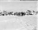
| Date: | 1918 |
|---|---|
| Description: | View across snow towards four soldiers standing near brush piles. Two men standing in the center, and two men stand behind the brush, defending the road to... |
| Date: | 1835 |
|---|---|
| Description: | This map covers the Western Territory of the United States from the Rocky Mountains in Colorado south to Fort Smith, Arkansas, and from the Pacific Ocean e... |

| Date: | 1950 |
|---|---|
| Description: | Intended for tourists, this brochure features two maps with tourists sites along the Mississippi River. One map shows roads and populated places along the ... |

| Date: | 1853 |
|---|---|
| Description: | This map shows camps, forts, logging camps, lakes, roads, railroads, the Wisconsin River, and Lac Du Flambeau Indian Reservation. Some points of interest a... |

| Date: | 1837 |
|---|---|
| Description: | This map shows the planned military posts/depots, roads, existing forts, rivers, and land assigned to various Indian tribes. Illinois, Mississippi, Arkansa... |

| Date: | 1837 |
|---|---|
| Description: | This map shows planned military posts/depots, barracks, rivers, lakes, roads, existing forts, and land assigned to various Indian tribes. Arkansas, Illinoi... |
If you didn't find the material you searched for, our Library Reference Staff can help.
Call our reference desk at 608-264-6535 or email us at: