 Filter: Categories of Wisconsin Historical Images
Filter: Subject of Roads
Filter: Subject of camps
Filter: Categories of Wisconsin Historical Images
Filter: Subject of Roads
Filter: Subject of camps
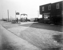
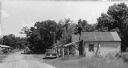
| Date: | 10 23 1934 |
|---|---|
| Description: | Hope Corners with sign for "Hope Tourist Camp: Groceries, Cabins, Garage" featuring Standard Service, Red Crown Gasoline, Quaker State Oil & Penzoil. 3737 ... |

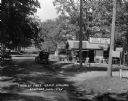
| Date: | 06 11 1931 |
|---|---|
| Description: | View down road towards the Log Cabin tourist camp at 6611 University Avenue. |
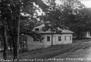
| Date: | 1926 |
|---|---|
| Description: | Caption reads: "Chapel at Willerup Camp — Lake Ripley — Cambrdige. Wis." The camp was named for the Danish immigrant minister, Christian B. Willerup, who e... |
| Date: | 1925 |
|---|---|
| Description: | Free public campground at Baraboo, one of 200 such facilities then made available to the traveling public by Wisconsin municipalities. |

| Date: | 1925 |
|---|---|
| Description: | A view of the 7-acre Hallelujah Campground which was located at the corner of Janesville Street and South Perry Parkway in the Village of Oregon. According... |

| Date: | |
|---|---|
| Description: | A vine-covered arched trellis with a yoke hanging from it is over the path leading into the camp. A camp building is in the background. Caption reads: "Pau... |
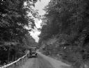
| Date: | |
|---|---|
| Description: | A view of a car on a dirt road driving toward Mt. Tom Camp, with a wooden guardrail on one side and a natural rock formation on the other side. |
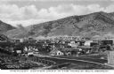
| Date: | |
|---|---|
| Description: | Elevated view of a copper mining camp with desert hills in the background. Caption reads: "Greatest Copper Camp in the World, Ely, Nevada." |
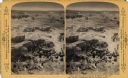
| Date: | 1893 |
|---|---|
| Description: | A depiction of Jerusalem on the day of Jesus' crucifixion. This is the road to Joppa and a camp of Bedouin Arabs. Text at right: "Wanderings Among the Wond... |
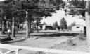
| Date: | 1938 |
|---|---|
| Description: | Landscaped grounds under large white pine trees in the foreground, buildings in the background. A man is walking along the stone-lined road on the left, an... |

| Date: | 1925 |
|---|---|
| Description: | This map shows state trunk highways, county trunk highways, railroads, canoe trails, lakes, and free public camp sites. The map on the reverse also shows a... |
| Date: | 1966 |
|---|---|
| Description: | Buildings along an unpaved road served as a camp for migrant farm workers working for the Green Bay Food Company. In 1946, more than 4,000 farmworkers fr... |
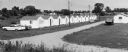
| Date: | 1967 |
|---|---|
| Description: | A central Wisconsin labor camp consisting of a row of wooden framed building with asphalt siding which housed migrant laborers. At the center, three childr... |

| Date: | 1926 |
|---|---|
| Description: | This Wisconsin Conservation Commission map from the 1920s shows roads, railroads, campsites, lookout towers, and privately owned lands in Northern Forest S... |

| Date: | 1916 |
|---|---|
| Description: | This Wisconsin Conservation Commission map from 1916 shows Peninsula State Park in the Town of Gibraltar, Door County, Wisconsin. Depicted are open and pla... |

| Date: | 1916 |
|---|---|
| Description: | This version of a 1916 Wisconsin Conservation Commission map shows Peninsula State Park in the Town of Gibraltar, Door County, Wisconsin. Depicted are open... |

| Date: | 1902 |
|---|---|
| Description: | This 1902 map of the eastern portion of Sawyer County, Wisconsin, shows the township and range system, sections, roads, farm houses, camps, school houses, ... |

| Date: | 1926 |
|---|---|
| Description: | This 1926 map depicts resorts and camps, lakes and streams, railroads, and roads in portions of Vilas, Iron, Oneida, Price, and Lincoln counties in Wiscons... |

| Date: | 1967 |
|---|---|
| Description: | This tourist brochure for Bayfield County, Wisconsin, from 1967 includes a map of the county showing towns, cities and villages, highways and roads, railro... |

| Date: | 1900 |
|---|---|
| Description: | Shows lands belonging to Wisconsin Timber and Land Co., towns, post offices, saw mills, creameries, camps, churches, schools, farm houses, town halls, rail... |
If you didn't find the material you searched for, our Library Reference Staff can help.
Call our reference desk at 608-264-6535 or email us at: