Filter: Categories of Wisconsin Historical Images
Filter: Subject of Roads
Filter: Reproduction Rights of For Sale
Filter: Subject of barracks
Filter: Categories of Wisconsin Historical Images
Filter: Subject of Roads
Filter: Reproduction Rights of For Sale
Filter: Subject of barracks
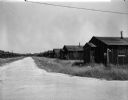
| Date: | 1942 |
|---|---|
| Description: | Correspondents' hut from across the main road, Port Moresby, New Guinea. Photograph taken between October and December, 1942. |
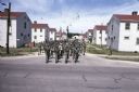
| Date: | 06 1977 |
|---|---|
| Description: | Troops in uniform march on a street at Camp McCoy. There are barracks on either side of the road. One soldier carries a U.S. flag while others carry smalle... |
| Date: | 1945 |
|---|---|
| Description: | View from road of vines and flower boxes brightening an otherwise unremarkable row of barracks type housing. There is an A & P Food Store on the right, wit... |
| Date: | |
|---|---|
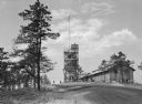
| Description: | View looking uphill toward two men standing on a road near a tall lookout tower with a flag on a flagpole, and barracks at Camp Upton, active starting in 1... |
| Date: | |
|---|---|
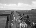
| Description: | A view of sailors in uniform standing between the rows of barracks of the United States Naval Training Station. |
| Date: | 1918 |
|---|---|
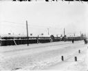
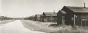
| Description: | View across snow covered road of the quarters of the 310th U.S. Army Corps of Engineers, Company C Quarters behind a timber fence. There are pedestrians in... |
| Date: | 1918 |
|---|---|
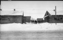
| Description: | View from snowy road towards a group of men standing among barracks occupied by Army units from Michigan. |
| Date: | |
|---|---|
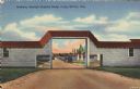
| Description: | Colorized postcard view of an arch at Camp McCoy with ramps on either side and a road passing through it. Parked cars and barracks are on the far side of t... |
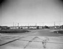
| Date: | 1947 |
|---|---|
| Description: | Abandoned enlisted men's barracks at Truax Field. |

| Date: | 1837 |
|---|---|
| Description: | This map shows planned military posts/depots, barracks, rivers, lakes, roads, existing forts, and land assigned to various Indian tribes. Arkansas, Illinoi... |
| Date: | 1967 |
|---|---|
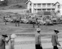
| Description: | Men are walking in the foreground. In the background more men, in uniform, stand near several International Payscrapers parked in Phan Rang, Vietnam. Recen... |

| Date: | 03 1777 |
|---|---|
| Description: | Map showing the British and Hessian attack on Fort Washington in November of 1776. The movements and fortifications of the British and Hessian troops appea... |

| Date: | 1761 |
|---|---|
| Description: | Map of New Orleans with north oriented towards the upper right corner. It shows the land around the city, the Mississippi River, anchorages, roads leading ... |
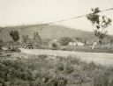
| Date: | 1935 |
|---|---|
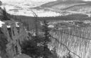
| Description: | Elevated view, from the South Bluff, of the CCC camp at Devil's Lake State Park. There is a rock outcropping in the foreground on the left. South Shore Roa... |
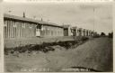
| Date: | 1935 |
|---|---|
| Description: | External view of the barracks for the Civilian Conservation Corps at Marengo. |
If you didn't find the material you searched for, our Library Reference Staff can help.
Call our reference desk at 608-264-6535 or email us at: