 Filter: Categories of Wisconsin Historical Images
Filter: Subject of Roads
Filter: County of Washington
Filter: Categories of Wisconsin Historical Images
Filter: Subject of Roads
Filter: County of Washington

| Date: | 1879 |
|---|---|
| Description: | Bird's-eye map of Hartford. |

| Date: | 1878 |
|---|---|
| Description: | Bird's-eye map of Kewaskum. Includes a list of hotels, churches, post office, railroad depot, etc. |

| Date: | 1915 |
|---|---|
| Description: | Plat map of Polk township in Washington County. |

| Date: | 1946 |
|---|---|
| Description: | Man mows grass with an International A tractor and mower. Caution flags are mounted on the tractor. Original caption reads: "International A used with an I... |

| Date: | 06 12 1998 |
|---|---|
| Description: | "Barth's Linden Inn is located on the West shore of Big Cedar Lake, between Slinger and West Bend on Hwy. 144." From left to right; Ralph "Buddy" Ruecker, ... |
| Date: | 10 24 2003 |
|---|---|
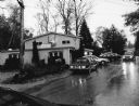
| Description: | "On a cool, rainy evening, we visit the Country Inn on Silver Lake. Their address is 5602 Peters Drive, West Bend." |

| Date: | 10 1948 |
|---|---|
| Description: | "This overhead at Addison carried Hwy 41 (later Hwy 175) over Hwy 33." |

| Date: | |
|---|---|
| Description: | Letterhead of the Kewaskum Mutual Fire Insurance Company of Washington County, Wisconsin, with a Native American man wearing buckskin clothes and leggings ... |
| Date: | 1969 |
|---|---|
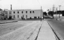
| Description: | Site of Libby McNeil and Libby canning company. In 1968, workers in Hartford staged a walkout to support Obreros Unidos (United Workers) to show dissatisfa... |

| Date: | 1859 |
|---|---|
| Description: | This 1859 map of Washington County, Wisconsin, shows the township and range grid, towns, sections, landownership and acreages, cities and villages, roads, ... |

| Date: | 1976 |
|---|---|
| Description: | This 1976 map of Washington County, Wisconsin, shows towns, cities and villages, highways and roads, existing and proposed county trails, and various publi... |

| Date: | 1899 |
|---|---|
| Description: | This 1899 map shows the contour depths of Big Cedar Lake in Washington County, Wisconsin, and includes four cross sections of the lake. Roads, railroads, s... |

| Date: | 1910 |
|---|---|
| Description: | This 1910 map from the U.S. Post Office Dept. shows rural delivery routes, active and discontinued post offices, collection boxes, selected rural landowner... |

| Date: | 1929 |
|---|---|
| Description: | Map shows townships and sections, landownership and acreages, roads, schools, school districts, churches, and cemeteries. Includes index of acreage tracts. |
| Date: | |
|---|---|
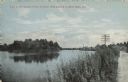
| Description: | Colorized postcard view of the Milwaukee River from the road. There are buildings in the background on the right. Caption reads: "View of Milwaukee River o... |

| Date: | 1911 |
|---|---|
| Description: | Hand-colored bird's eye view of Cedar Lake with various resorts labeled. Caption reads: "Cedar Lake, Washington Co. Wisconsin; Looking East, Wisconsin." |

| Date: | 1906 |
|---|---|
| Description: | View of the water tower. A stable is to the right at the base of the tower on the right. Other buildings are in the background on the left. Caption reads: ... |

| Date: | |
|---|---|
| Description: | Watercolor reproduction, with key, of the area surrounding Holy Hill (19.) which is at top center, and below are Lake Keesus (J.) and the town of Merton (1... |

| Date: | |
|---|---|
| Description: | Photographic postcard view of a wood frame hotel with a long porch. Caption reads: "Hillside Hotel, Holy Hill, Wis. B. Heileman, Prop." |

| Date: | |
|---|---|
| Description: | View across fields towards the town of Hubertus. Caption reads: "Birds Eye [sic] View, Hubertus, Wis." |
If you didn't find the material you searched for, our Library Reference Staff can help.
Call our reference desk at 608-264-6535 or email us at: