Filter: Categories of Wisconsin Historical Images
Filter: Subject of Roads
Filter: County of Sauk
Filter: Year of 1800-1899
Filter: Categories of Wisconsin Historical Images
Filter: Subject of Roads
Filter: County of Sauk
Filter: Year of 1800-1899

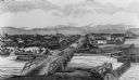
| Date: | 1870 |
|---|---|
| Description: | Baraboo was first settled around 1838, and by 1870 it had become the county seat and the thriving village illustrated here. This birds eye drawing depicts ... |

| Date: | 1870 |
|---|---|
| Description: | Bird's-eye map of Prairie du Sac. |

| Date: | 1870 |
|---|---|
| Description: | Sauk City is the oldest incorporated village in Wisconsin (incorporated in 1854) and also has the oldest organized volunteer fire department in the state, ... |

| Date: | 1883 |
|---|---|
| Description: | Bird's-eye map of Prairie du Sac, Wisconsin with an inset of Clifton. |
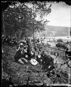
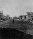
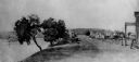
| Date: | 1877 |
|---|---|
| Description: | Well-dressed young couples sit in the foreground. In the background is a picket fence running along a busy road with horse and buggy traffic. Further on is... |
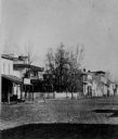
| Date: | 1875 |
|---|---|
| Description: | View of the west side of Water Street. |
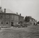
| Date: | 1880 |
|---|---|
| Description: | View of unpaved Water Street, featuring a group of patrons standing in the entrance of A. Becker's Saloon. |
| Date: | 1868 |
|---|---|
| Description: | View of the west side of unpaved Water Street, looking south. |
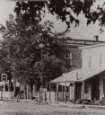
| Date: | 1868 |
|---|---|
| Description: | View of unpaved Water Street, showing a millinery shop. |
| Date: | 1868 |
|---|---|
| Description: | View of Water Street looking north from the business district. |
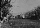
| Date: | 1875 |
|---|---|
| Description: | View of unpaved Water Street south of the Highway 12 intersection, looking north. Bluffs are in the distance. |
| Date: | 1850 |
|---|---|
| Description: | Buildings along Wisconsin River. |

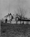
| Date: | 1870 |
|---|---|
| Description: | View towards the front of a house with a white fence. Posing in front of the fence are a man (appears to be on crutches), a young child, and a dog. Other p... |

| Date: | 1877 |
|---|---|
| Description: | This 1877 map of Sauk County, Wisconsin, shows the township and range grid, sections, towns, cities and villages, land ownership and acreages, wagon roads,... |

| Date: | 1859 |
|---|---|
| Description: | Shows townships and sections, landownership, roads, railroads, rural residences, schools, churches, and topography. Relief shown by hachures. "From governm... |
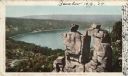
| Date: | 1898 |
|---|---|
| Description: | Colorized postcard view of the Devil's Doorway rock formation overlooking Devil's Lake. Caption reads: "Devil's Doorway, Devil's Lake, Wis." |

| Date: | 07 1870 |
|---|---|
| Description: | This map of Ironton is pen-and-ink on paper and shows lots and block numbers, mill, foundry buildings, limestone quarry, iron mine, and roads. Relief is sh... |

| Date: | 1861 |
|---|---|
| Description: | This map shows townships and sections, landownership, roads, railroads, rural residences, schools, churches, and topography. Also included are inset maps o... |
If you didn't find the material you searched for, our Library Reference Staff can help.
Call our reference desk at 608-264-6535 or email us at: