 Filter: Categories of Wisconsin Historical Images
Filter: Subject of Roads
Filter: County of Door
Filter: Categories of Wisconsin Historical Images
Filter: Subject of Roads
Filter: County of Door
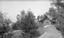
| Date: | 1924 |
|---|---|
| Description: | A stone lined driveway leads to the Hotz family cottage on Europe Lake. |
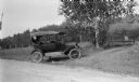
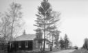
| Date: | 07 15 1919 |
|---|---|
| Description: | The photographer's automobile parked at the entrance to his cherry orchard. A sign on the gate offers a $25 reward for information on anyone stealing fruit... |
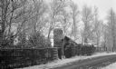
| Date: | 1920 |
|---|---|
| Description: | View of the stone garage and tower at the Hotz Fish Creek compound on Egg Harbor Road, now Highway 42. There is a rustic lattice fence and gate along the r... |
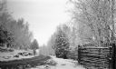
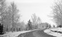
| Date: | 04 1920 |
|---|---|
| Description: | A late snow covers the trees and a rustic fence along Egg Harbor Road, now Highway 42, near the Hotz cottages outside of Fish Creek. |
| Date: | 04 1920 |
|---|---|
| Description: | Snow clings to trees and fences along Egg Harbor Road near the Hotz cottages. |
| Date: | 1925 |
|---|---|
| Description: | Three women pose on the steps of the Baptist Church at Ellison Bay, which has an open bell tower. A car is parked a short distance down the dirt road. |

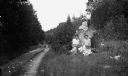
| Date: | 1912 |
|---|---|
| Description: | View down dirt road leading to the Carlson farm at Nelson Bay in Peninsula State Park. A man stands in the background among the farm buildings near a parke... |
| Date: | 1910 |
|---|---|
| Description: | The photographer's wife, Clothilde, sits, (right) in front of a rock with an unidentified woman, as daughters Alice, standing, and Helen pose on top of the... |
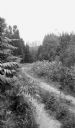
| Date: | 1925 |
|---|---|
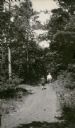
| Description: | A dirt road winds through Peninsula State Park. |
| Date: | 1919 |
|---|---|
| Description: | A child and an adult follow a small herd of cattle walking up the dirt road, now Highway 42, north out of Sister Bay. The bell tower of Zion Lutheran Churc... |

| Date: | 1920 |
|---|---|
| Description: | A car is parked along a narrow dirt road with a house, barn and outbuildings in the background. A split-rail fence lines the left side of the road. There i... |
| Date: | 1924 |
|---|---|
| Description: | Two men walk away from the camera, down a narrow country road. Both are wearing knickers and knee socks; the man on the left wears a hat and carries a walk... |

| Date: | 1922 |
|---|---|
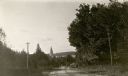
| Description: | View from hill of cherry trees in bloom in the Gibraltar Orchard on Sturgeon Bay Road (Highway 42.) |

| Date: | 05 1919 |
|---|---|
| Description: | Elevated view across Sturgeon Bay Road, now Highway 42, toward the Gibraltar Orchard cherry camp. There is a wooden fence in the foreground, and the camp c... |

| Date: | 1916 |
|---|---|
| Description: | This Wisconsin Conservation Commission map from 1916 shows Peninsula State Park in the Town of Gibraltar, Door County, Wisconsin. Depicted are open and pla... |

| Date: | 1916 |
|---|---|
| Description: | This version of a 1916 Wisconsin Conservation Commission map shows Peninsula State Park in the Town of Gibraltar, Door County, Wisconsin. Depicted are open... |

| Date: | 1872 |
|---|---|
| Description: | This 1872 map shows the proposed route of a canal between Sturgeon Bay, on the Green Bay side of the Door Peninsula, and Lake Michigan. Depths in both Stur... |
| Date: | 1915 |
|---|---|
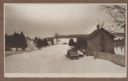
| Description: | Winter scene from Egg Harbor Road (Highway 42) in Fish Creek looking north toward frozen Fish Creek Harbor with the bluffs in Peninsula State Park beyond. ... |

| Date: | 1915 |
|---|---|
| Description: | An older story and a half wood frame house with a one-story addition on the left and lean-to on the right stands near the Green Bay shore. It is identified... |

| Date: | 1860 |
|---|---|
| Description: | This map of Dodge County, Wisconsin, shows the township and range grid, towns, sections, cities and villages, railroads, roads, property owners and acreage... |
If you didn't find the material you searched for, our Library Reference Staff can help.
Call our reference desk at 608-264-6535 or email us at: