 Filter: Categories of Wisconsin Historical Images
Filter: Subject of Roads
Filter: Community of Wisconsin Dells
Filter: Year of 1900-1999
Filter: Year of 1930-1939
Filter: Categories of Wisconsin Historical Images
Filter: Subject of Roads
Filter: Community of Wisconsin Dells
Filter: Year of 1900-1999
Filter: Year of 1930-1939

| Date: | 1930 |
|---|---|
| Description: | Exterior view of the Triangle filling station on Highway 12, which sold gasoline, ice, and other items. A man stands in front by the gas pump, and a map of... |

| Date: | 1930 |
|---|---|
| Description: | This pictorial map from the first half of the 20th century shows the landmarks, highways, rail lines, and cities and villages in the vicinity of the Wiscon... |

| Date: | 1935 |
|---|---|
| Description: | This 1935 map shows the Wisconsin River from a point approximately 4 miles south of the city of Wisconsin Dells north to Duck Creek in Adams County. Sectio... |

| Date: | 1931 |
|---|---|
| Description: | View from side of road towards main building of Nettland's Roll Inn, with a service station, restaurant and registration office for their campsites. A grou... |

| Date: | 1931 |
|---|---|
| Description: | Three-quarter view from road of a guest house with a large porch. A large sign on the lawn in front advertises running water in the rooms and a rate of $1 ... |

| Date: | 1931 |
|---|---|
| Description: | Exterior view from road of the White House Hotel. There is a trellis with four columns at the sidewalk entrance that leads to a long porch with rocking cha... |
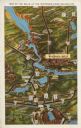
| Date: | 1931 |
|---|---|
| Description: | Text on front reads: "Map of the Dells of the Wisconsin River Region." On reverse: "All the world knows of the Wisconsin Dells. Many noted travelers have p... |
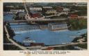
| Date: | 1935 |
|---|---|
| Description: | Text on front reads: "Bird's-eye View of Riverview Service Group, Looking East, At The Dells, Wisconsin Dells, Wisconsin." On reverse: "All the world knows... |
If you didn't find the material you searched for, our Library Reference Staff can help.
Call our reference desk at 608-264-6535 or email us at: