 Filter: Categories of Wisconsin Historical Images
Filter: Subject of Roads
Filter: Community of Wisconsin Dells
Filter: Subject of lakes
Filter: Categories of Wisconsin Historical Images
Filter: Subject of Roads
Filter: Community of Wisconsin Dells
Filter: Subject of lakes

| Date: | 1935 |
|---|---|
| Description: | This 1935 map shows the Wisconsin River from a point approximately 4 miles south of the city of Wisconsin Dells north to Duck Creek in Adams County. Sectio... |
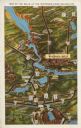
| Date: | 1931 |
|---|---|
| Description: | Text on front reads: "Map of the Dells of the Wisconsin River Region." On reverse: "All the world knows of the Wisconsin Dells. Many noted travelers have p... |
If you didn't find the material you searched for, our Library Reference Staff can help.
Call our reference desk at 608-264-6535 or email us at: