Filter: Categories of Wisconsin Historical Images
Filter: Subject of Roads
Filter: Community of Milwaukee
Filter: Categories of Wisconsin Historical Images
Filter: Subject of Roads
Filter: Community of Milwaukee
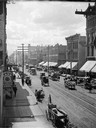
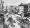
| Date: | 1885 |
|---|---|
| Description: | Elevated view of West Water Street from Grand Avenue of horse-drawn vehicles, pedestrians, buildings, storefronts and power lines. |
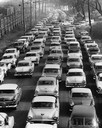
| Date: | 1957 |
|---|---|
| Description: | Elevated view of city traffic of bumper-to-bumper cars leaving Milwaukee County Stadium after the 1957 World Series. |
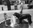
| Date: | 07 20 1987 |
|---|---|
| Description: | A little girl offers her place at a fountain to a large Newfoundland-mix dog who takes a drink on a hot day. |
| Date: | 1870 |
|---|---|
| Description: | Buildings along Wisconsin Avenue lining a wide dirt road. |
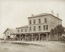
| Date: | 1880 |
|---|---|
| Description: | 2504 Forest Home Avenue. This hotel was situated on what was originally a plank road between Milwaukee and Muskego. It was designed after the Federal style... |
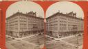
| Date: | 1880 |
|---|---|
| Description: | Stereograph of elevated view of Newhall House which was destroyed by fire in 1883. |
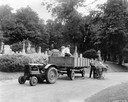
| Date: | 1935 |
|---|---|
| Description: | Workers tending the grounds of the Forest Home Cemetery using a McCormick-Deering I-12 tractor and wagon. |
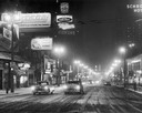
| Date: | 12 01 1955 |
|---|---|
| Description: | Neon lights up Wisconsin Avenue on a winter night in Milwaukee. |

| Date: | 11 16 2001 |
|---|---|
| Description: | Aerial view of General Mitchell International in Milwaukee, looking southeast to the Lake Michigan shoreline. |

| Date: | 1882 |
|---|---|
| Description: | Bird's-eye views of various sections of Milwaukee. |

| Date: | 1898 |
|---|---|
| Description: | Bird's-eye map, looking west from shoreline on Lake Michigan of Milwaukee to Golden Lake in Waukesha County, with Kenosha and Fox Point at bottom corners, ... |

| Date: | 1927 |
|---|---|
| Description: | Color map, hand-drawn with comic figures engaged in various activities throughout map. Bordered by the river on the left and Lake Michigan on the right, in... |
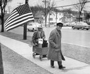
| Date: | 11 10 1956 |
|---|---|
| Description: | Bet winner and Eisenhower supporter Edwin L. Warner enjoys his payoff from bet loser and Adlai Stevenson backer John Shaat, as Shaat tows Warner along the ... |

| Date: | 1857 |
|---|---|
| Description: | From Judge Smith Addition, 5th Ward, looking north, toward the city. Drawing is an elevated view of field and plank fence in foreground, road to the left a... |

| Date: | 1854 |
|---|---|
| Description: | Bird's-eye view of Milwaukee looking east toward Lake Michigan from a bluff, long since graded into a slope, at about 6th Street between Wisconsin Avenue a... |

| Date: | 1937 |
|---|---|
| Description: | Bird's-eye view of Milwaukee in 1853 details building features and city layout from southwest. Important buildings are numbered in a silhouette drawing bel... |
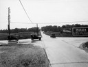
| Date: | 1918 |
|---|---|
| Description: | The intersection of Port Washington Road and Silver Spring Drive near Milwaukee. Even if one did not know that this was the intersection of a major north-s... |
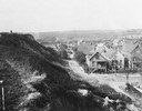
| Date: | 1925 |
|---|---|
| Description: | Elevated view from a hill of an alley connecting Park Hill Avenue and Mount Vernon Avenue, looking west from the Interurban Line. There is a person on top ... |
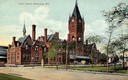
| Date: | 1908 |
|---|---|
| Description: | Union Depot with clock tower. The railroad station with clock tower is behind a park. Horse-drawn vehicles are near the entrance. Caption reads: "Union Dep... |
If you didn't find the material you searched for, our Library Reference Staff can help.
Call our reference desk at 608-264-6535 or email us at: