 Filter: Categories of Wisconsin Historical Images
Filter: Subject of Roads
Filter: Community of Madison
Filter: Categories of Wisconsin Historical Images
Filter: Subject of Roads
Filter: Community of Madison
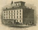
| Date: | 1853 |
|---|---|
| Description: | Illustration of the Capital house, a first-class hotel, copied from page 320 of Gleason's Pictorial Drawing-Room Companion. |

| Date: | 1867 |
|---|---|
| Description: | Bird's-eye map of Madison with insets of the University, Rasdall House, Vilas House, and the Wisconsin State Capitol. View includes cattail marsh, smokesta... |

| Date: | 1885 |
|---|---|
| Description: | Bird's-eye map of Madison, State Capital of Wisconsin, County Seat of Dane County, with inset of the Wisconsin State Capitol. |

| Date: | 1852 |
|---|---|
| Description: | Pencil drawing of Madison landscape as seen from University Hill. The main street in the center is State Street, and the building with Greek columns in the... |

| Date: | 1852 |
|---|---|
| Description: | Pencil drawing of view overlooking Madison. The sketch looks down North Hamilton Street from the capitol. Rutted, irregular streets and frame houses mark ... |
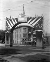
| Date: | 1898 |
|---|---|
| Description: | Wisconsin Semi-Centennial ceremonial archway erected at State and Mifflin Streets to celebrate Admiral George Dewey's victory over the Spanish fleet at Man... |
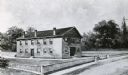
| Date: | 1848 |
|---|---|
| Description: | Sketch of the Madison Women's Seminary on the corner of Wisconsin Avenue and East Johnson. The Madison Female Academy was a 19th century school for girls w... |
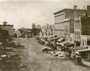
| Date: | 1859 |
|---|---|
| Description: | Daguerreotype of elevated view of Pinckney Street, looking northwest. View includes the American House and Bruen's Block, both on the corner of East Washin... |
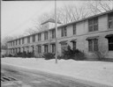
| Date: | 04 01 1945 |
|---|---|
| Description: | Kleinheinz Hall (old Sheep Barn) at 1815 Linden Drive on University of Wisconsin campus. |
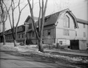
| Date: | 03 01 1945 |
|---|---|
| Description: | Kleinheinz Hall (old Sheep Barn) at 1815 Linden Drive on University of Wisconsin-Madison campus. Building was used as housing for United States Navy Radio ... |
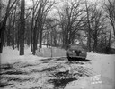
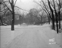
| Date: | 01 19 1945 |
|---|---|
| Description: | Winter scene with automobile parked in front of barricade at west end of Edgewood Drive. |
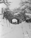
| Date: | 01 19 1945 |
|---|---|
| Description: | Looking towards the stone bridge on Edgewood Drive. |
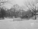
| Date: | 01 19 1945 |
|---|---|
| Description: | Barricades at the east end of Edgewood Drive. |
| Date: | 01 19 1945 |
|---|---|
| Description: | Close-up of barricades at the east end of Edgewood Drive. |
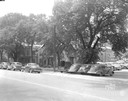
| Date: | 06 20 1944 |
|---|---|
| Description: | Cars parked in the 200 block of West Washington Avenue. Properties shown are, right to left, Fiore Filling Station parking lot, U.S. Government warehouse (... |

| Date: | 09 30 1943 |
|---|---|
| Description: | Broken sign for Cities Service Station, 2408 University Avenue. Millers' Super Market, at 2418 University Avenue, is in the background. |
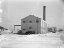
| Date: | 01 22 1943 |
|---|---|
| Description: | Hospital heating building at Truax Army Air Field, from the west side. |
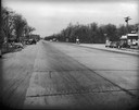
| Date: | 1941 |
|---|---|
| Description: | Accident scene at Femrites' Corner, taken from Highway 12 & 18 looking west past Highway 51 (Monona Drive). |
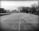
| Date: | 1941 |
|---|---|
| Description: | Accident scene at Femrites' Corner taken from Highway 51 (Monona Drive) looking south to the intersection with Highway 12 & 18. |
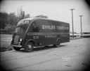
| Date: | 10 11 1940 |
|---|---|
| Description: | Whalen Transfer & Storage Co. medium size moving van no. 18. |
If you didn't find the material you searched for, our Library Reference Staff can help.
Call our reference desk at 608-264-6535 or email us at: