 Filter: Categories of Wisconsin Historical Images
Filter: Subject of Roads
Filter: Community of Gettysburg
Filter: Categories of Wisconsin Historical Images
Filter: Subject of Roads
Filter: Community of Gettysburg
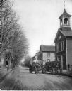
| Date: | |
|---|---|
| Description: | View toward the fire engine which is parked in the middle of the street. To the right, parked next to the curb, is the wagon that carries the fire fighters... |

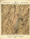
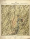
| Date: | 1876 |
|---|---|
| Description: | Detailed topographic map of the Gettysburg battlefield created thirteen years after the battle. This map shows day one of the battle. The map shows drainag... |

| Date: | 1863 |
|---|---|
| Description: | These detailed topographical maps of the Battle of Gettysburg show drainage, vegetation, roads, railroads, fences, houses with names of residents, and a de... |

| Date: | 1863 |
|---|---|
| Description: | These detailed topographical maps of the Battle of Gettysburg show drainage, vegetation, roads, railroads, fences, houses with names of residents, and a de... |

| Date: | 1863 |
|---|---|
| Description: | This map shows drainage, vegetation, roads, railroads, fences, dwellings with names of inhabitants, and land owned by the United States. Union and Confeder... |
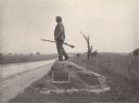
| Date: | 1903 |
|---|---|
| Description: | Statue of John L. Burns, the elderly citizen-hero of the Battle of Gettysburg, who fought with the 7th Wisconsin on July 1, 1863 and was wounded. A veteran... |
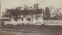
| Date: | 1890 |
|---|---|
| Description: | View across road towards the house where General Reynolds' body was taken after he was killed on the first day of the Battle of Gettysburg. |
| Date: | 1876 |
|---|---|
| Description: | Detailed topographic map of the Gettysburg battlefield created thirteen years after the battle. This map shows day two of the battle. The map shows drainag... |
| Date: | 1876 |
|---|---|
| Description: | Detailed topographic map of the Gettysburg battlefield created thirteen years after the battle. This map shows day three of the battle. The map shows drain... |
If you didn't find the material you searched for, our Library Reference Staff can help.
Call our reference desk at 608-264-6535 or email us at: