 Filter: Categories of Wisconsin Historical Images
Filter: Subject of Roads
Filter: Community of Beloit
Filter: Categories of Wisconsin Historical Images
Filter: Subject of Roads
Filter: Community of Beloit

| Date: | 1890 |
|---|---|
| Description: | Bird's-eye map of Beloit with insets of Williams Engine Works, Eclipse Wind Engine Co., and John Foster & Co. Turtle Creek is in the lower section, and the... |
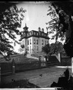
| Date: | 1875 |
|---|---|
| Description: | View across wooden platform of a brick high school on a hill surrounded by a fence. The school has a mansard roof and what appears to be a bell tower above... |
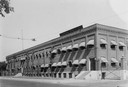
| Date: | |
|---|---|
| Description: | Faribands, Morse & Co. Building, with power lines in the background. |
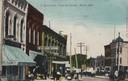
| Date: | 1905 |
|---|---|
| Description: | The 5 and 10 cent store, with the Yale bakery, and a restaurant on East Grand Avenue visible from the bridge. Caption reads: "E. Grand Ave., form the Bridg... |
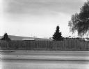
| Date: | 04 1980 |
|---|---|
| Description: | View across stateline road towards a wooden fence lining the road on the opposite side. A few trees and buildings can be seen over the fence. |

| Date: | |
|---|---|
| Description: | View across small section of road (Huebbe Parkway?) towards a mowed field. A large power or telephone tower rises above a group of trees, and more towers a... |

| Date: | |
|---|---|
| Description: | A sign prominently displays "OPEN THANKSGIVING DAI" in the top left corner of the frame. Across Third Street behind the sign is the 88 Tavern. Down Portlan... |

| Date: | 11 18 1979 |
|---|---|
| Description: | An electrical box on a wooden pole is in the center foreground. Behind it is a street, and on the other side of the street is a Phillips 66 service station... |

| Date: | |
|---|---|
| Description: | An electric sign for "The Manor / 2 Blocks / Dining" towers over a long, one-story building. |
| Date: | 04 16 1980 |
|---|---|
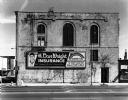
| Description: | View from across street of a rectangular dilapidated building featuring arched windows. A billboard for H. Dan Wright Insurance is under the fire escape. |

| Date: | |
|---|---|
| Description: | East facing view from the Upper Bridge, featuring the Beloit water tower in the distance. |

| Date: | 1910 |
|---|---|
| Description: | Colorized postcard view from riverbank of the Upper Bridge crossing the Rock River into Beloit. A man is in a rowboat in the foreground. In the background ... |
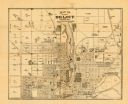
| Date: | 1887 |
|---|---|
| Description: | This map of Beloit shows labeled wards, plat of town, roads, railroads, the Rock River, city boundaries, and land ownership by name. The back of the map is... |
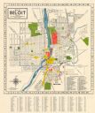
| Date: | 1952 |
|---|---|
| Description: | This colorful map of Beloit shows roads, railroads, rivers, creeks, business districts, industrial areas, and parks and recreation areas. The map includes ... |
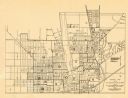
| Date: | 1953 |
|---|---|
| Description: | This map of Beloit shows existing platted streets or highways and proposed street right of way. The map reads: "I hereby certify that this is the official ... |
If you didn't find the material you searched for, our Library Reference Staff can help.
Call our reference desk at 608-264-6535 or email us at: