Filter: Categories of Wisconsin Historical Images
Filter: Subject of Rivers
Filter: Year of 1800-1899
Filter: Year of 1890-1899
Filter: Categories of Wisconsin Historical Images
Filter: Subject of Rivers
Filter: Year of 1800-1899
Filter: Year of 1890-1899
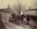
| Date: | 1898 |
|---|---|
| Description: | Horse-drawn carriage stuck in a rut on a muddy road near the Ohio River in Floyd County, Indiana. One man is holding the horse while another attempts to di... |
| Date: | 1899 |
|---|---|
| Description: | View along shoreline towards Indian log drivers, two in a bateau, and one man standing on the bank of the Chippewa River. |
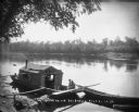
| Date: | 1896 |
|---|---|
| Description: | Two men, one wearing an apron, sit in a wanigan tied to the shore of the Chippewa River near Chippewa Falls. The inside of the boat appears to have a pile ... |
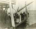
| Date: | 1895 |
|---|---|
| Description: | The sidewheel excursion, Saint Paul, after running aground near Muscatine. The spar is set and the line out. Dan Sauer, the carpenter, is holding th... |
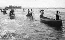
| Date: | 07 16 1898 |
|---|---|
| Description: | A group of Ojibwa men fishing from boats. |
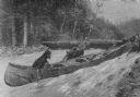
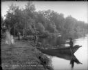
| Date: | 03 1892 |
|---|---|
| Description: | Three men are dragging their canoe upriver through a strong current. In the background other men are standing on the far river bank near canoes pulled up o... |

| Date: | 1890 |
|---|---|
| Description: | Portion of the plat map of the north part of Caledonia in Columbia County, including explanations. |

| Date: | 1890 |
|---|---|
| Description: | Plat map of the south part of Caledonia in Columbia County. |
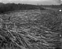
| Date: | 1895 |
|---|---|
| Description: | Logs move down the river, swirling with cross currents, resulting in a huge log jam. |

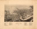
| Date: | 1890 |
|---|---|
| Description: | Bird's-eye map of Beloit with insets of Williams Engine Works, Eclipse Wind Engine Co., and John Foster & Co. Turtle Creek is in the lower section, and the... |
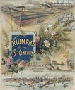
| Date: | 1893 |
|---|---|
| Description: | Cover of an advertising catalog for William Deering & Company featuring chromolithograph illustrations of the Deering factory, the grain center of the worl... |

| Date: | 1898 |
|---|---|
| Description: | Bird's-eye map of Milwaukee with prominent streets and buildings identified. Taken from City Hall Tower. |

| Date: | 1896 |
|---|---|
| Description: | Bird's-eye map of Darlington. Area bordered by Washington and North Streets, upper left hand corner, the fairgrounds, upper right corner, River Street, bot... |

| Date: | 1891 |
|---|---|
| Description: | Bird's-eye view of Eau Claire. |

| Date: | 1893 |
|---|---|
| Description: | This photocopy of a bird’s-eye-view map shows illustrated houses and various buildings. Streets and the Rock River are labeled. An index to points of inter... |

| Date: | 1893 |
|---|---|
| Description: | Bird's-eye map of Green Bay and Fort Howard, looking south. Ninety-four locations identified below image; extends to Grignon Street at top left corner, Wi... |

| Date: | 1892 |
|---|---|
| Description: | This bird's-eye view map is oriented looking north-east and includes index of points of interest and businesses. The map is a photocopy. |
If you didn't find the material you searched for, our Library Reference Staff can help.
Call our reference desk at 608-264-6535 or email us at: