 Filter: Categories of Wisconsin Historical Images
Filter: Subject of Rivers
Filter: Year of 1800-1899
Filter: Community of Eau Claire
Filter: Categories of Wisconsin Historical Images
Filter: Subject of Rivers
Filter: Year of 1800-1899
Filter: Community of Eau Claire

| Date: | 1872 |
|---|---|
| Description: | Birds-eye drawing of Eau Claire depicts street names and street locations, houses, trees, bridges, piers, canals, railroads, and the Chippewa and Eau Clair... |

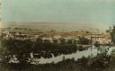
| Date: | 1891 |
|---|---|
| Description: | Bird's-eye view of Eau Claire. |
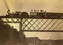
| Date: | 09 01 1882 |
|---|---|
| Description: | View looking up towards the special train of the Chicago, St. Paul, Minneapolis & Omaha Railroad comprised of 24 freight cars loaded with lumber and other ... |
| Date: | 1880 |
|---|---|
| Description: | View from high bank across the river of the Ingram and Pinkum sawmill (left), Ingram and Kennedy mill (right), later incorporated as the Empire Lumber Co. ... |

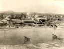
| Date: | 1870 |
|---|---|
| Description: | Elevated view of the town, looking northwest. The Chippewa River is in the foreground, with a lot of buildings, an intersection, and distant hills. One bui... |
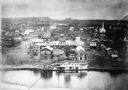
| Date: | 1870 |
|---|---|
| Description: | View of the town and Chippewa river, with a steamboat in the center along the riverbank. A smaller boat is next to the steamboat, with a man standing eithe... |
| Date: | 1880 |
|---|---|
| Description: | The sawmill of Gilbert E. Porter and Delos R. Moon was located on the Chippewa River approximately three miles southwest of the city of Eau Claire. In 1873... |

| Date: | 1868 |
|---|---|
| Description: | The river steamer Chippewa drawn up alongside shore on the West Eau Claire Levee. The steamer was built by Captain E.E. Heerman at La Crosse in 1866... |

| Date: | 1875 |
|---|---|
| Description: | Shows land ownership by name, local streets, buildings, cemeteries, Chippewa River, and Half Moon Lake. Includes 1 inset map of Eau Claire. Also includes c... |

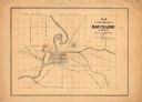
| Date: | 1877 |
|---|---|
| Description: | Relief shown by hachures. Shows land ownership by name, wards, railroads, mills, dams, city limits, Chippewa River, and Half Moon Lake. Includes index of m... |

| Date: | 1877 |
|---|---|
| Description: | Relief shown by hachures. Shows land ownership by name, wards, railroads, mills, dams, city limits, Chippewa River, and Half Moon Lake. Includes index of m... |

| Date: | 1889 |
|---|---|
| Description: | Shows city limits, railroads, mills, schools, cemeteries, dams, parks, lumber yards, log canals, log reservoir, Chippewa River, Eau Claire River, and Half ... |
| Date: | 1860 |
|---|---|
| Description: | This map has relief shown by hachures and shows roads, railroads, proposed railroads, creeks, Half Moon Lake, Mount Adin, Mount Tom, Mount Sumeon, and part... |

| Date: | 1880 |
|---|---|
| Description: | View of a lumber mill and logs floating on a river, which is spanned by a bridge. The mill has a sign that reads: "Cash for Wheat - Eau Claire City Mill." ... |
If you didn't find the material you searched for, our Library Reference Staff can help.
Call our reference desk at 608-264-6535 or email us at:
