 Filter: Categories of Wisconsin Historical Images
Filter: Subject of Rivers
Filter: Subject of transportation, military
Filter: Categories of Wisconsin Historical Images
Filter: Subject of Rivers
Filter: Subject of transportation, military
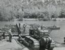
| Date: | 1958 |
|---|---|
| Description: | Soldier using an International TD-18 crawler tractor (TracTracTor) during a training exercise. The original caption reads: "A graduate of the school assign... |

| Date: | 08 08 1919 |
|---|---|
| Description: | Elevated view up the Milwaukee River from Wisconsin Avenue bridge. A World War I submarine travels down the Milwaukee River. A crowd is gathered at the riv... |
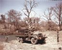
| Date: | 1952 |
|---|---|
| Description: | Color photograph of an M-139 truck transporting members of a bridge-building unit and construction materials to the bank of a river in a wooded area. The s... |
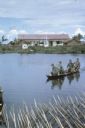
| Date: | 06 1962 |
|---|---|
| Description: | U.S. Army advisor Major M.C. Curley and soldiers crossing a river in the delta region of Vietnam in a small boat to visit an outpost. A large building, a m... |

| Date: | 11 1961 |
|---|---|
| Description: | Sea Swallows, an anti-communist Vietnamese militia, begin an operation by boats on a canal in the vicinity of Van Dinh, Vietnam. Militia members hold guns ... |

| Date: | 06 1962 |
|---|---|
| Description: | Aerial view of old U.S. Army model H-21 helicopter, assigned to help Vietnamese forces fight the Viet Cong in the mountain region of Vietnam. The patchwork... |
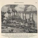
| Date: | 1887 |
|---|---|
| Description: | Engraving of Pittsburg Landing taken from a photograph a few days after the Battle of Shiloh (Tennessee), which occurred on April 6-7, 1862. The image sho... |
| Date: | 1944 |
|---|---|
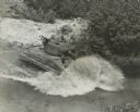
| Description: | Elevated view of a tank fording a river. Two soldiers are standing in the hatches on the gun turret, with another soldier in a partially opened hatch below... |

| Date: | 10 13 1943 |
|---|---|
| Description: | Aerial view of two Consolidated B-24 Liberator warplanes taken from another airplane during the Alexishafen strike. On the left is Colonel Arthur Rogers' l... |

| Date: | 1758 |
|---|---|
| Description: | Map showing lakes, rivers, cities, Native American land, and the boundaries of French and English claims in America and Canada north of New York. A title c... |

| Date: | 1780 |
|---|---|
| Description: | Detailed map of America east of the Louisiana region. It shows forts, cities, borders and boundary lines, Native American land, the post road, mountains, w... |

| Date: | 1780 |
|---|---|
| Description: | Detailed topographical and political map of the area from Lake Champlain to Albany and the Hudson River. Relief is shown through hachures. The map shows ci... |

| Date: | 02 1777 |
|---|---|
| Description: | Map depicting the campaigns of October and November 1776, in Manhattan, Westchester, and part of New Jersey, published only a few months after the conclusi... |

| Date: | 11 1781 |
|---|---|
| Description: | Map of New York, Staten Island, and Long Island, showing the placements of forts, and the movement of troops in 1776. The map also includes towns, cities, ... |

| Date: | 04 1777 |
|---|---|
| Description: | Map showing the area from Newtown, Pennsylvania to Kingston, New Jersey, with routes and battles of British (red) and American forces (blue). The map inclu... |

| Date: | 1915 |
|---|---|
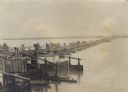
| Description: | Austrian cavalrymen crossing a floating bridge over the Save River during World War I. |
| Date: | 1914 |
|---|---|
| Description: | Soldiers crossing the floating war bridge over the Save River during World War I. |

| Date: | 1914 |
|---|---|
| Description: | Soldiers and civilians carrying supplies for repairing bad roads in enemy territory during World War I. |
| Date: | 1914 |
|---|---|
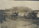
| Description: | A car and a wagon are crossing the bridge over the Danube in World War I. Pedestrians are using the walkway of the bridge on the left. |
| Date: | 1914 |
|---|---|
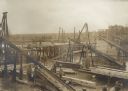
| Description: | Austrian military engineers building a bridge over the Dunajec River in Galicia. |
If you didn't find the material you searched for, our Library Reference Staff can help.
Call our reference desk at 608-264-6535 or email us at: