Filter: Categories of Wisconsin Historical Images
Filter: Subject of Rivers
Filter: Subject of human settlements
Filter: Categories of Wisconsin Historical Images
Filter: Subject of Rivers
Filter: Subject of human settlements
| Date: | |
|---|---|
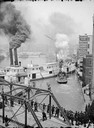
| Description: | Elevated view of a Milwaukee River scene showing people watching several steamboats from a bridge. |
| Date: | |
|---|---|
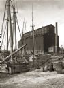
| Description: | View of old sailing boats at a shoreline with elevator A in the background. |
| Date: | 11 08 1906 |
|---|---|
| Description: | Two Civil War watercolor drawings by John Gaddis, Company E, 12th Wisconsin Volunteer Infantry, showing the regiment in bivouac, and later their headquarte... |
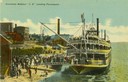
| Date: | 1901 |
|---|---|
| Description: | The sternwheel excursion, J.S., landing passengers, taken between 1901 and 1910. Crowds are on riverbank and there are buildings in background. A cr... |
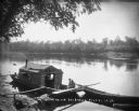
| Date: | 1896 |
|---|---|
| Description: | Two men, one wearing an apron, sit in a wanigan tied to the shore of the Chippewa River near Chippewa Falls. The inside of the boat appears to have a pile ... |
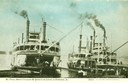
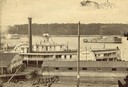
| Date: | |
|---|---|
| Description: | The Saint Paul, Silver Crescent, and Quincy at the levee. Gangplanks are lowered and passengers are disembarking. Caption reads: "St. ... |
| Date: | |
|---|---|
| Description: | The whaleback "Christopher Columbus" in the Chicago River. Caption reads: "STR. 'Christopher Columbus'." |
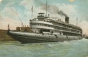
| Date: | 1900 |
|---|---|
| Description: | The sternwheel excursion, "Thistle" on the river behind a building. Previously named J.H. Crawford. The "Thistle" ran between Oshkosh and Omro, via Butte d... |
| Date: | 1863 |
|---|---|
| Description: | Elevated view of the steamboat Golden Era, which did service during the Civil War, docked near buildings. It was sold to Michael Purcell of New Orle... |

| Date: | 1861 |
|---|---|
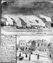
| Description: | Drawn the first year of the Civil War, this colored 1861 map of Dane County shows its towns, cities and lakes. It includes insets of the wards of Madison a... |
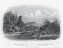
| Date: | 1832 |
|---|---|
| Description: | Engraving of Indians on horseback along river with Indian grave on hill in background. |

| Date: | 1853 |
|---|---|
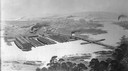
| Description: | Bird's-eye map of Milwaukee looking east toward Lake Michigan from a bluff, long since graded into a slope, at about 6th Street between Wisconsin Avenue an... |

| Date: | |
|---|---|
| Description: | Map of the district of the Peshtigo fire, approximately 1,280,000 acres, in Wisconsin and Upper Michigan. |
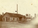
| Date: | 1919 |
|---|---|
| Description: | Deering Works factory seen across the waterfront from Diversey Avenue. In the foreground is a street and sidewalk with the sign "horse vehicles keep to rig... |

| Date: | 1951 |
|---|---|
| Description: | Aerial view of the Nekoosa-Edwards Paper Company nursery. |

| Date: | 1885 |
|---|---|
| Description: | Bird's-eye view of Watertown with indexed points of interest. |

| Date: | 1862 |
|---|---|
| Description: | Drawn the second year of the Civil War, this 1862 map of Milwaukee shows post offices, light houses, beacon lights, county buildings, elevator warehouses, ... |

| Date: | |
|---|---|
| Description: | A car advertisement for a 1966 Chevelle on a billboard in a small unidentified Appalachian town. |
If you didn't find the material you searched for, our Library Reference Staff can help.
Call our reference desk at 608-264-6535 or email us at: