 Filter: Categories of Wisconsin Historical Images
Filter: Subject of Rivers
Filter: Subject of human settlements
Filter: County of Barron
Filter: Categories of Wisconsin Historical Images
Filter: Subject of Rivers
Filter: Subject of human settlements
Filter: County of Barron
| Date: | |
|---|---|
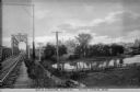
| Description: | View along railroad tracks leading towards a railroad bridge across the Red Cedar River. A large building is on the opposite shoreline. Caption reads: "Red... |

| Date: | 1912 |
|---|---|
| Description: | This early 20th century map of Barron County, Wisconsin, shows the township and range grid, towns, sections, cities and villages, railroads, roads, houses,... |

| Date: | 1969 |
|---|---|
| Description: | This map shows businesses, resorts, roads, public boat landings, schools, cemeteries, and location of fish and game. An inset map reads: Continuation along... |

| Date: | 1960 |
|---|---|
| Description: | This map shows improved town roads, federal highways, county highways, public boat access, public hunting areas, railroads, and lakes in the area around th... |
| Date: | |
|---|---|
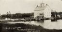
| Description: | View from shoreline across water towards the Norwestern Flour and Grain Company mill on the banks of a river. Caption reads: "Norwestern Flour and Grain Co... |

| Date: | 1947 |
|---|---|
| Description: | Text on front reads: "Greetings-Rice Lake, Wis." A country road curves into the distance next to a river. On the right, a rocky bluff was excavated for the... |
If you didn't find the material you searched for, our Library Reference Staff can help.
Call our reference desk at 608-264-6535 or email us at: