 Filter: Categories of Wisconsin Historical Images
Filter: Subject of Rivers
Filter: County of Polk
Filter: Categories of Wisconsin Historical Images
Filter: Subject of Rivers
Filter: County of Polk
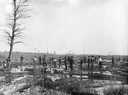
| Date: | 1902 |
|---|---|
| Description: | The Goar and Stinson log driving crew on the Clam River. |

| Date: | 05 1926 |
|---|---|
| Description: | Section 1 of a Sanborn map of Osceola. |

| Date: | 05 1926 |
|---|---|
| Description: | Section 2 of a Sanborn map of Osceola. |
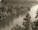
| Date: | 1940 |
|---|---|
| Description: | Elevated view of a canoe on the St. Croix River with wooded areas on both sides within the Interstate State Park. Established in 1900, Interstate Park was... |

| Date: | 1926 |
|---|---|
| Description: | A brochure with a map of Interstate Park on the Dalles of the Saint Croix River, showing locations of the north and south camp grounds, the fish hatcheries... |
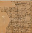
| Date: | |
|---|---|
| Description: | This map of Polk County, Wisconsin, from the first half of the 20th century, shows the township and range grid, towns, sections, villages, roads, railroads... |

| Date: | 1901 |
|---|---|
| Description: | Map shows townships, schools, creameries, post offices, and roads. The left side of the map features a legend with symbols for points of interest. |

| Date: | 1914 |
|---|---|
| Description: | Map shows townships, schools, creameries, post offices, and roads. The left side of the map features a legend with symbols for points of interest. |

| Date: | 1890 |
|---|---|
| Description: | Map shows St. Croix, Wisconsin and a small portion of Taylor's Falls, Minnesota. Map reads: "The Lands shaded show the Mill & Riparian Reservation & unplat... |

| Date: | 1969 |
|---|---|
| Description: | Map showing St. Croix Falls and Taylors Falls, Minnesota. The map was produced by the St. Croix Falls Chamber of Commerce and Taylor Falls Commercial Club.... |
| Date: | 1940 |
|---|---|
| Description: | Photographic postcard view across water towards rock formations along the St. Croix River in Interstate State Park. "Caption reads: "Angle Rock Bend on the... |
| Date: | 1940 |
|---|---|
| Description: | A retouched photographic postcard view across water towards rock formations along the St. Croix River in Interstate State Park. The caption reads: "LaCroix... |
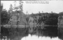
| Date: | 1940 |
|---|---|
| Description: | Photographic postcard elevated view of the St. Croix River in Interstate State Park, with a large rock outcropping and pine trees in the foreground. Captio... |

| Date: | 1914 |
|---|---|
| Description: | Text on front reads: "Interstate Park. Dells of the St. Croix." Elevated view of the Dells of the St. Croix River between Wisconsin and Minnesota. Text on ... |

| Date: | 1907 |
|---|---|
| Description: | Text on front reads: "The Birches. Inter-State Park. Taylors Falls Minn." Taylors Falls is crossed out and "On Wisconsin Side" is handwritten on the revers... |

| Date: | 1912 |
|---|---|
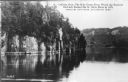
| Description: | Text on front reads: "Dalles of the St. Croix, Inter State Park, Minnesota and Wisconsin." Elevated view of the St. Croix River showing the rock formations... |

| Date: | 1907 |
|---|---|
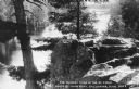
| Description: | Text on front reads: "The Dalles of the St. Croix River, Wisconsin." Elevated view of the St. Croix River showing the rock formation "Devil's Chair" in the... |
If you didn't find the material you searched for, our Library Reference Staff can help.
Call our reference desk at 608-264-6535 or email us at: