 Filter: Categories of Wisconsin Historical Images
Filter: Subject of Rivers
Filter: County of Milwaukee
Filter: Type of Map or Atlas
Filter: Categories of Wisconsin Historical Images
Filter: Subject of Rivers
Filter: County of Milwaukee
Filter: Type of Map or Atlas

| Date: | 1862 |
|---|---|
| Description: | Drawn the second year of the Civil War, this 1862 map of Milwaukee shows post offices, light houses, beacon lights, county buildings, elevator warehouses, ... |

| Date: | 1898 |
|---|---|
| Description: | Bird's-eye map of Milwaukee with prominent streets and buildings identified. Taken from City Hall Tower. |

| Date: | 1872 |
|---|---|
| Description: | Bird's-eye map of Milwaukee on Lake Michigan. |

| Date: | 1898 |
|---|---|
| Description: | Bird's-eye map, looking west from shoreline on Lake Michigan of Milwaukee to Golden Lake in Waukesha County, with Kenosha and Fox Point at bottom corners, ... |

| Date: | 1927 |
|---|---|
| Description: | Color map, hand-drawn with comic figures engaged in various activities throughout map. Bordered by the river on the left and Lake Michigan on the right, in... |

| Date: | 1876 |
|---|---|
| Description: | Made from U.S. Surveys and from minutes furnished by Jos. S. Buck and Dr. C. Chase. Scale 20 CHs to an inch. |

| Date: | 1882 |
|---|---|
| Description: | This basic reference map of the state shows natural features, railroads, county seats, and political boundaries against the G.L.O. township and range grid.... |

| Date: | 1906 |
|---|---|
| Description: | Polyconic projection. Map made from surveys without spirit level control. Henry Gannett, Chief Topographer. Topography by Van H. Manning and Nat. Tyler, Jr... |

| Date: | 1908 |
|---|---|
| Description: | Colored map in perspective indicates railroad routes. Lake Winnebago and Oshkosh in center, area extends to Shawano (top right corner), Green Bay (bottom r... |

| Date: | 1853 |
|---|---|
| Description: | Plan no. 3. Scale 2000 feet to one inch. |

| Date: | 1833 |
|---|---|
| Description: | Published in James Smith Buck's, "Pioneer History of Milwaukee". Lake Michigan is on the right, with three rivers that combine at different points and reac... |

| Date: | 1833 |
|---|---|
| Description: | Drawing on a faint grid with Lake Michigan on the right, and the rivers on the left. Labeled is an Indian Village, J. Veiu, S. Juneau, and P. Juneau. Alo... |

| Date: | 1878 |
|---|---|
| Description: | This map shows block numbers, wards, roads, railroads, parks, and selected buildings and includes a "Milwaukee city street guide" as well as a guide to pub... |

| Date: | 1836 |
|---|---|
| Description: | This hand-colored manuscript map shows the township and section grid in southeastern Wisconsin, covering the area west to Sugar River and Four Lakes region... |

| Date: | 05 1846 |
|---|---|
| Description: | Hand-colored map of southeastern Wisconsin showing the counties of Dodge, Jefferson, Rock, Walworth, Racine (including modern-day Kenosha County), Waukesha... |

| Date: | 1844 |
|---|---|
| Description: | An ink on paper, hand-drawn map of Milwaukee County that shows the sectioning of townships, the boundary of the canal grant, roads, streams, lakes, includi... |
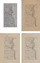
| Date: | 1875 |
|---|---|
| Description: | A series of four, ink on tracing cloth maps of Milwaukee County, Wisconsin that show the topography, the Milwaukee and Menomonee rivers, and railroad of th... |

| Date: | 1976 |
|---|---|
| Description: | An 1876 reprinted map of the Township of Franklin, Milwaukee County, Wisconsin, that shows the land ownership and sectioning of the town, as well as the ro... |

| Date: | 1886 |
|---|---|
| Description: | A hand-colored map of Milwaukee County, Wisconsin that shows the township and range system, sections, towns, roads, railroads and rail stations, cities and... |
If you didn't find the material you searched for, our Library Reference Staff can help.
Call our reference desk at 608-264-6535 or email us at:
