 Filter: Categories of Wisconsin Historical Images
Filter: Subject of Rivers
Filter: County of Dane
Filter: Year of 1800-1899
Filter: Categories of Wisconsin Historical Images
Filter: Subject of Rivers
Filter: County of Dane
Filter: Year of 1800-1899

| Date: | 1873 |
|---|---|
| Description: | Map of the township of Windsor, from the "Atlas of Dane County." |

| Date: | 1861 |
|---|---|
| Description: | Drawn the first year of the Civil War, this colored 1861 map of Dane County shows its towns, cities and lakes. It includes insets of the wards of Madison a... |

| Date: | 1876 |
|---|---|
| Description: | Bird's-eye view of Black Earth. |

| Date: | 1839 |
|---|---|
| Description: | This map shows the hydrology of Madison and its vicinity at the height of interest in a proposed Milwaukee and Rock River Canal. It was made by Thomas Jeff... |

| Date: | 1839 |
|---|---|
| Description: | A map of the Wiskonsin [sic] and Neenah or Fox Rivers. |

| Date: | 1832 |
|---|---|
| Description: | Hand-drawn map in two parts of the route of Governor J.D. Doty. Probably made by Doty in 1832 as a result of his travels with Alexander J. Center. |

| Date: | 1836 |
|---|---|
| Description: | The top map is the "Plat of Madison the Capitol of Wisconsin." The bottom map is the "Map of the Four Lake Country. Taken from the Township Maps in the U.S... |

| Date: | 1875 |
|---|---|
| Description: | Bird's-eye map of Mazomanie. |

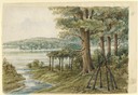
| Date: | 1873 |
|---|---|
| Description: | Identified as " Lover's Retreat, Spring View." Group in field with stream on a picnic. Children are stepping on stones in foreground with U.S. flag, people... |
| Date: | 1858 |
|---|---|
| Description: | Hölzlhuber's first extensive excursion in Wisconsin was a walking tour from Madison to Prairie du Sac along the Wisconsin River. He lost his way along Lake... |

| Date: | 1853 |
|---|---|
| Description: | Farwell's Mill on the Yahara River at Lake Mendota. |

| Date: | 1890 |
|---|---|
| Description: | Left half of a plat map of the "East Part of the city of Madison". |

| Date: | 1855 |
|---|---|
| Description: | Map of the city of Madison, Dane County, published by George Harrison, surveyed and drawn by P. McCabe, and engraved by J.H. Colton & Co., New York. In add... |
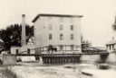
| Date: | 1890 |
|---|---|
| Description: | View towards the mill on the Yahara River at the outlet of Lake Mendota. The mill was built in 1850 by Governor Farwell. A man is standing on the bridge wi... |
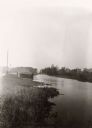
| Date: | 1897 |
|---|---|
| Description: | View along shoreline of the Yahara River, a small building along the shoreline near a road on the left. The Malt House is in the far background, prior to t... |
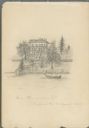
| Date: | 08 31 1885 |
|---|---|
| Description: | Pencil on paper drawing of large house on hill above river, with rowboat and boathouse. The house has three stories, four chimneys, mansard roof, and long... |
If you didn't find the material you searched for, our Library Reference Staff can help.
Call our reference desk at 608-264-6535 or email us at:


