 Filter: Categories of Wisconsin Historical Images
Filter: Subject of Rivers
Filter: County of Dane
Filter: Categories of Wisconsin Historical Images
Filter: Subject of Rivers
Filter: County of Dane
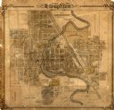
| Date: | 1906 |
|---|---|
| Description: | This map of Stoughton shows plat additions, numbered lots, some land ownership, and labeled streets. The map is color coded in blue, pink, and yellow altho... |

| Date: | 1873 |
|---|---|
| Description: | A map of the township of Primrose from the "Atlas of Dane County." |

| Date: | 1873 |
|---|---|
| Description: | A map of the township of Montrose from the "Atlas of Dane County." |

| Date: | 1861 |
|---|---|
| Description: | The township of Primrose, which is a detail from the plat map of Dane County. |

| Date: | 1861 |
|---|---|
| Description: | The township of Montrose, which is a detail from a Dane County plat map. |

| Date: | 08 14 1960 |
|---|---|
| Description: | Members of the 58th annual Inland Lake Yachting Association regatta social committee discuss social events for the regatta on the Edgewater Hotel pier. Sho... |

| Date: | 06 11 1960 |
|---|---|
| Description: | Three motor boats cruise on the Yahara river near the East Johnson Street bridge. A concrete boat ramp is visible at right with three additional motor boat... |

| Date: | 1911 |
|---|---|
| Description: | A plat map of the township of Westport in Dane County. |

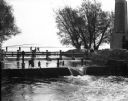
| Date: | 08 03 1953 |
|---|---|
| Description: | Boaters passing by through the Tenney Park lock in three motor boats. |

| Date: | 1901 |
|---|---|
| Description: | View along the Catfish River, with shrubs and grasses covering the riverbank. On the far left are electrical poles along a dirt road bordering a field that... |

| Date: | 04 1905 |
|---|---|
| Description: | Map of the Madison, Wisconsin region showing the four major lakes, starting in the north with Lake Mendota, Lake Monona, Lake Waubesa, and Lake Kegonsa. La... |

| Date: | |
|---|---|
| Description: | A house laced straight into the wiry sore of righteousness, squared off and lonely, tingling at the sound of ice, the libertine who drowned. |

| Date: | 1910 |
|---|---|
| Description: | This maps is pen and pencil on tracing cloth and shows local streets, buildings, proposed and present branches of railroad track, and sewer and water lines... |

| Date: | 1945 |
|---|---|
| Description: | This maps shows roads, railroads, parks, recreational areas, Lake Wingra, Lake Monona, and part of Lake Mendota. The map includes pictorial images that dep... |

| Date: | 1899 |
|---|---|
| Description: | A plat map showing Lake Monona, the isthmus in Madison, and the towns of Burke and Blooming Grove. |

| Date: | 03 28 1964 |
|---|---|
| Description: | The University of Wisconsin crew is rowing down the Yahara River on a practice run, the four oarsmen stirring the water as they go. |

| Date: | |
|---|---|
| Description: | View down dirt road towards a tall smokestack near the Yahara River bridge where the river flows into Lake Mendota. The smokestack is the remainder of Leon... |
| Date: | |
|---|---|
| Description: | View across the Yahara River towards a tall smokestack on the opposite shoreline, with Lake Mendota in the background. Remnants of the foundation and suppo... |

| Date: | |
|---|---|
| Description: | View across lawn and the Yahara River towards the Hausmann Brewing Company's Malt House in the center background. On the right is the Yahara River bridge. ... |

| Date: | 03 1965 |
|---|---|
| Description: | Keith Brigham is shown checking the U.S. Geological Survey stream gauging station located at the Yahara river locks on Lake Waubesa near McFarland. |
If you didn't find the material you searched for, our Library Reference Staff can help.
Call our reference desk at 608-264-6535 or email us at: