 Filter: Categories of Wisconsin Historical Images
Filter: Subject of Rivers
Filter: Community of Green Bay
Filter: Categories of Wisconsin Historical Images
Filter: Subject of Rivers
Filter: Community of Green Bay

| Date: | 1961 |
|---|---|
| Description: | This map shows established harbor lines, local streets, railroads, U.S. government channel, and part of Fox River. The map includes a table of reference po... |

| Date: | 1987 |
|---|---|
| Description: | This map pictorially shows local roads, local businesses with phone numbers, and parts of Fox River and bay of Green Bay. |

| Date: | 1951 |
|---|---|
| Description: | This map has depths shown by bathymetric tints and soundings and relief shown by contours, the depths are shown in feet. There is an inset map of Green Bay... |

| Date: | 1914 |
|---|---|
| Description: | This map has relief shown by hachures and shows local streets, wards, districts, railroads, Fox River, and part of Bay of Green Bay. Wards are shown in dar... |

| Date: | 1874 |
|---|---|
| Description: | This map shows streets, buildings, railroads, the Fox River, the East River, and part of Green Bay. |

| Date: | 1906 |
|---|---|
| Description: | This map shows streets, railroads, land use, public buildings, commercial businesses, and the Menominee River. Depths are shown by gradient tints and sound... |

| Date: | 1907 |
|---|---|
| Description: | Sanborn map of Green Bay including St. George and Main Streets. |

| Date: | 1907 |
|---|---|
| Description: | Sanborn map of Green Bay featuring Elm, Cedar and Main Streets. |

| Date: | 1900 |
|---|---|
| Description: | This photostat map was probably originally created in 1835 and shows in addition to private claims, mills, roads, and trails. Green Bay and the Fox River a... |

| Date: | 1900 |
|---|---|
| Description: | This photocopied map shows private claim owners, buildings, and land use in 1818. Insets show Fort Howard and the caption reads: "A view of the Fox River ... |

| Date: | 1921 |
|---|---|
| Description: | This map shows various zones in a proposed city ordinance. Also shown are creeks, streets, parks, hospitals, cemeteries, and the Fox River. A legend is inc... |

| Date: | 1862 |
|---|---|
| Description: | This map shows landownership on a military reserve, private claims, buildings (including Fort Howard and U.S. sawmill), swamps, public barns and fields, an... |

| Date: | 1960 |
|---|---|
| Description: | This map is a facsimile of a 1829 map and shows private land claims, landowners within military reserve boundaries, sawmill, Fort Howard, public barns, bri... |

| Date: | 04 11 1940 |
|---|---|
| Description: | This blue line print map shows survey monument markers by type and industrial buildings and covers part of the lower Fox River and East River. The map incl... |

| Date: | 1850 |
|---|---|
| Description: | This map shows the location of planned blocks and lot numbers, street names, and docks along the Fox River and canal. |

| Date: | 1917 |
|---|---|
| Description: | View over the wing of a Lawson Military Tractor 2 (MT2) in flight. Below are houses and what may be a river or lake. Location is unknown, but is probably n... |

| Date: | 1835 |
|---|---|
| Description: | Map shows the Fox River, lot and block numbers, private claims, streets, a public squares, a manual labour school, and Fort Howard. An inset map shows a pl... |

| Date: | 1900 |
|---|---|
| Description: | This set of maps contains four sheets: "Landownership in the Vicinity of Military Reserve and Fort Howard," "Houses Along the River Road to Green Bay," "Ow... |
| Date: | |
|---|---|
| Description: | Aerial view of Green Bay, and the Fox River headed toward the bay. Commercial and industrial buildings are on the right bank, and residential neighborhoods... |

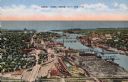
| Date: | |
|---|---|
| Description: | Elevated view of the Fox River at Green Bay. Warehouses and factories are along the riverfront, and a drawbridge is spanning the river in the background. |
If you didn't find the material you searched for, our Library Reference Staff can help.
Call our reference desk at 608-264-6535 or email us at: